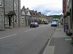
Tomintoul
Tomintoul
|
|
|---|---|
 |
|
| Tomintoul shown within Moray | |
| Population | 322 (Census 2001) |
| OS grid reference | NJ165185 |
| Council area | |
| Lieutenancy area | |
| Country | Scotland |
| Sovereign state | United Kingdom |
| Post town | BALLINDALLOCH |
| Postcode district | AB37 |
| Dialling code | 01807 |
| Police | Scottish |
| Fire | Scottish |
| Ambulance | Scottish |
| EU Parliament | Scotland |
| UK Parliament | |
| Scottish Parliament | |
Tomintoul (![]() i/ˌtɒmᵻnˈtaʊl/; from Scottish Gaelic: Tom an t-Sabhail, meaning "Hillock of the Barn") is a village in the Moray council area of Scotland; until 1975 it was in the county of Banffshire.
i/ˌtɒmᵻnˈtaʊl/; from Scottish Gaelic: Tom an t-Sabhail, meaning "Hillock of the Barn") is a village in the Moray council area of Scotland; until 1975 it was in the county of Banffshire.
It is said to be the highest village in the Scottish Highlands, but at 345 m (1,132 ft) is still much lower than the highest village in Scotland (Wanlockhead, in Dumfries and Galloway).
The village was laid out on a grid pattern by the 4th Duke of Gordon in 1775. It followed the construction, twenty years previously, of a military road by William Caulfeild – now the A939. By 1841 the parish reached a population of 1,722. In 1951 this had fallen to just 531. The 2001 census reveals a village population of 322 with the total parish population now unavailable.
...
Wikipedia

