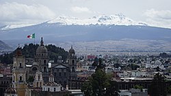
Toluca de Lerdo
| Toluca, Mexico | |||
|---|---|---|---|
| City and municipality | |||
| Toluca de Lerdo | |||

Toluca in March 2013
|
|||
|
|||
 Location of Toluca in the State of Mexico |
|||
| Coordinates: 19°17′33″N 99°39′25″W / 19.29250°N 99.65694°W | |||
| Country |
|
||
| State |
|
||
| Region | Toluca | ||
| Metro area | Greater Toluca | ||
| Municipal Status | December 13, 1812 | ||
| Municipal Seat | Toluca de Lerdo | ||
| Government | |||
| • Type | Ayuntamiento | ||
| • Municipal President | Fernando Zamora Morales | ||
| Area | |||
| • Municipality | 452.37 km2 (174.66 sq mi) | ||
| • Water | 7.30 km2 (2.82 sq mi) | ||
| Elevation (of seat) | 2,660 m (8,730 ft) | ||
| Population (2010 Census) | |||
| • Municipality | 819,561 | ||
| Time zone | Central (US Central) (UTC-6) | ||
| • Summer (DST) | Central (UTC-5) | ||
| Postal code (of seat) | 50000 | ||
| Area code(s) | 722 / 729 | ||
| Demonym | Toluqueño (a) or tolucense (more formal) | ||
| Website | Official website (in Spanish) | ||
| Toluca | ||||||||||||||||||||||||||||||||||||||||||||||||||||||||||||
|---|---|---|---|---|---|---|---|---|---|---|---|---|---|---|---|---|---|---|---|---|---|---|---|---|---|---|---|---|---|---|---|---|---|---|---|---|---|---|---|---|---|---|---|---|---|---|---|---|---|---|---|---|---|---|---|---|---|---|---|---|
| Climate chart () | ||||||||||||||||||||||||||||||||||||||||||||||||||||||||||||
|
||||||||||||||||||||||||||||||||||||||||||||||||||||||||||||
|
||||||||||||||||||||||||||||||||||||||||||||||||||||||||||||
| J | F | M | A | M | J | J | A | S | O | N | D |
|
14
19
1
|
8.7
20
3
|
12
23
4
|
32
24
7
|
63
24
8
|
139
22
9
|
154
21
9
|
140
21
8
|
113
21
9
|
53
21
6
|
11
20
4
|
6.9
19
2
|
| Average max. and min. temperatures in °C | |||||||||||
| Precipitation totals in mm | |||||||||||
| Source: SMN | |||||||||||
| Imperial conversion | |||||||||||
|---|---|---|---|---|---|---|---|---|---|---|---|
| J | F | M | A | M | J | J | A | S | O | N | D |
|
0.6
66
34
|
0.3
69
37
|
0.5
73
40
|
1.2
75
44
|
2.5
75
46
|
5.5
72
49
|
6.1
69
48
|
5.5
70
47
|
4.5
69
47
|
...
| ||


