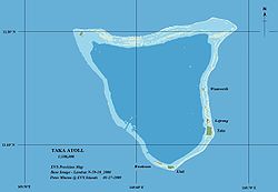
Toke Atoll

Map of Toke Atoll
|
|
| Geography | |
|---|---|
| Location | North Pacific |
| Coordinates | 11°17′N 169°37′E / 11.283°N 169.617°ECoordinates: 11°17′N 169°37′E / 11.283°N 169.617°E |
| Archipelago | Marshall Islands |
| Total islands | 6 |
| Major islands | 1 |
| Area | 36.18 sq mi (93.7 km2) |
| Highest elevation | 1 ft (0.3 m) |
| Administration | |
Toke Atoll or Taka Atoll (Marshallese: Tōkā, [tˠʌɡɑ͡ææ̯]) is a small, uninhabited coral atoll in the Ratak Chain of the Marshall Islands. It is one of the smaller atolls in the Marshalls and located at 11°17′N 169°37′E / 11.283°N 169.617°E. It is visited regularly by the residents of nearby Utirik Atoll.
The atoll is 160 kilometres (100 mi) north of Majuro Atoll, the capital of the Marshall Islands, and 10 kilometres (6.2 mi) southwest of Utirik Atoll. It comprises six islands with a combined land area of 0.57 square kilometres (0.22 sq mi) and a lagoon area of 93.1 square kilometres (35.96 sq mi).
The atoll is roughly triangular in shape, its length and width approximately 9 miles (14 kilometres). The highest point is 15 feet (4.6 metres) above sea level. The small land area is the second smallest in the Marshalls, besting only Bikar. Among its islets, only Toke, Eluk, and Lojrong are large enough to support permanent vegetation. The other sand islets have shown considerable shifting in size and location over the years. Ground water sampled from the midsection of Toke islet is brackish, with chloride levels of 440 to 840 ppm (compared to 19400 ppm for sea water) With a moderately shallow lagoon and single, deep, narrow western passage through the reef, Toke and its neighbor Utirik are an intermediate atoll type between the shallow, perched lagoons of Bokak and Bikar, and the deep lagoons and many reef passages of the central Marshall atolls.
...
Wikipedia

