Tohono O'odham Nation
| Tohono O'odham Nation | |||
|---|---|---|---|
| Reservation | |||
|
|||
 |
|||
| Established | 1874 (executive order) | ||
| Main expansions | 1882–1916 | ||
| First constitution | 1937 | ||
| tripartite system | 1986 | ||
| Capital | Sells, Arizona | ||
| Subdivisions | 11 districts | ||
| Government | |||
| • Body | Tohono O'odham Legislative Council | ||
| • Chairman | Edward D. Manuel | ||
| • Vice-Chairman | Verlon M. Jose | ||
| Area | |||
| • Total | 11,300 km2 (4,400 sq mi) | ||
| Population Enrolled tribal members | |||
| • Total | 28,000 | ||
| Time zone | MST/MDT | ||
| Website | www.tonation-nsn.gov | ||
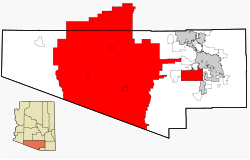
The Tohono O'odham Nation is the collective government body of the Tohono O'odham tribe in the United States. The Tohono O’odham Nation governs four separate pieces of land for a combined area of 2.8 million acres (11,330 km2), making it the second largest Native American land holding in the United States. These lands are located within the Sonoran Desert of south central Arizona and are directly exposed to the Mexico–United States border for 74 miles (119 km) along its southern border. The Nation is organized into 12 local districts and employs a tripartite system of government. Sells, Arizona is the Nation's largest community and functions as its capital. The Nation has approximately 28,000 enrolled members, the majority of whom live off of the reservations.
In 1874, President of the United States Ulysses S. Grant signed an executive order creating the San Xavier Indian Reservation, surrounding the 18th century Mission San Xavier del Bac. In 1882, President Chester A. Arthur signed an executive order creating the Gila Bend Indian Reservation as additional lands for the Tohono O’odham people. In 1916, a third reservation was created by executive order with Indian Oasis (now named Sells, Arizona) as its headquarters. In 1937, The Tohono O'odham Nation, then called the Papagos Tribe of Arizona, adopted their first constitution.
In 1960, the Army Corps of Engineers completed construction of the Painted Rock Dam on the Gila River. Flood waters impounded by the dam periodically inundated approximately 10,000 acres (40 km2) of the Gila Bend Indian Reservation. The area lost by the tribe contained a 750-acre (3.0 km2) farm and several communities. Residents were relocated to a 40-acre (160,000 m2) parcel of land named San Lucy Village, near Gila Bend, Arizona. In January 1986, the enrolled members of the three reservations adopted a new tribal constitution that changed the tribe name from Papago Tribe of Arizona to the Tohono O'odham Nation and adopted a three-branch form of government. Also in 1986, the federal government and the Nation approved a settlement in which the Nation agreed to give up its legal claims in exchange for $30,000,000 and the right to add replacement land to its reservation.
...
Wikipedia


