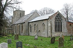
Tittleshall
| Tittleshall | |
|---|---|
 St Mary, Tittleshall |
|
| Tittleshall shown within Norfolk | |
| Area | 13.82 km2 (5.34 sq mi) |
| Population | 406 (2011 census) |
| • Density | 29/km2 (75/sq mi) |
| OS grid reference | TF 893 211 |
| Civil parish |
|
| District | |
| Shire county | |
| Region | |
| Country | England |
| Sovereign state | United Kingdom |
| Post town | KING'S LYNN |
| Postcode district | PE32 |
| Police | Norfolk |
| Fire | Norfolk |
| Ambulance | East of England |
| EU Parliament | East of England |
Tittleshall is a village and civil parish in the English county of Norfolk.
The village and parish of Tittleshall has an area of 1376 hectares or 13.82 km2 (5.34 sq mi). The parish is bordered to the north with the parishes of Raynham and Colkirk, to the west with Wellingham All Saints, to the south with the parishes of Litcham and Mileham and to the east with the parishes Whissonsett. The western edge of the parish also marks the border between the local government districts of Breckland, of which Tittleshall is part, and the district of King's Lynn and West Norfolk.
The Village is situated approximately 12 km (7.5 mi) south-west of the town of Fakenham, 18 km (11 mi) north-east of the town of Swaffham, and 40 km (25 mi) north-west of the city of Norwich.
In the 2011 census had a population of 406 in 161 households. For the purposes of local government, the parish falls within the district of Breckland.
The village name of Tittleshall is thought to derive from the Old English for Tyttel’s nook. The earliest evidence of human activity within the parish are a number of Neolithic pits and ditches as well as a prehistoric pit. At least three ring ditches have also been discovered, along with a double ring ditch containing cremation pits.
Tillleshall has an entry in the Domesday Book of 1085 where its population, land ownership and productive resources were extensively detailed. In the survey Tittleshall is recorded by the name of Titeshala. The main tenants were Wymer from William de Warenne, and Ralph Sturmy from Ralph Baynard. The survey also lists that for the Wymer tenancy, there had always been 7 smallholders on this land. Meadow 6 acres (24,000 m2), always 3½ ploughs, woodland, 40 pigs and 1 fishery. Value then 20s, now 30. For Ralph Sturmy’s tenancy there were 12 villagers, now 8. Then and later 4 smallholders, now 14. Then and later 6 slaves, now 2. Meadow 10 acres (40,000 m2), always 2 ploughs in lordship. Then and later 4 men’s ploughs, now 2. Woodland, 100 pigs; always 1 mill. Then 6 head of cattle. Then 30 pigs, now 19. Then 100 sheep, now 80. Then 40 goats, now 73. 4 beehives. Also 1 Freeman, acres 6 acres (24,000 m2). Value then 70s, now the same. Also 1 church, acres 6 acres (24,000 m2), value 5d. The whole has 9 furlongs in length and ½ league in width, tax 5d.
...
Wikipedia

