Tinian

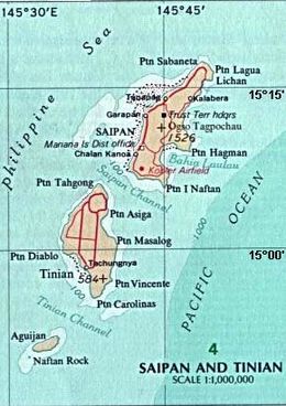
Tinian on an area map, southwest of Saipan, showing waters around islands, and deeper Pacific section.
|
|
| Geography | |
|---|---|
| Location | Pacific Ocean |
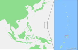
| Coordinates | 15°00′N 145°38′E / 15.000°N 145.633°E |
| Archipelago | Marianas |
| Area | 101.01 km2 (39.00 sq mi) |
| Highest elevation | 171 m (561 ft) |
| Highest point | Mount Lasso |
| Administration | |
|
United States
|
|
| Commonwealth | Northern Mariana Islands |
| Largest settlement | San Jose |
| Demographics | |
| Population | 3,136 (2010) |
Tinian (/ˈtɪniən/ or /ˌtiːniˈɑːn/) is one of the three principal islands of the Commonwealth of the Northern Mariana Islands. Together with uninhabited neighboring Aguijan, it forms Tinian Municipality, one of the four constituent municipalities of the Northern Marianas. Tinian's largest village is San Jose.
Tinian is about 5 nautical miles (9.3 km) southwest of Saipan, from which it is separated by the Saipan Channel. It has a land area of 39 square miles (100 km2), with its highest elevation at Mount Lasso at 171 meters (561 ft).
The island has a variety of flora and fauna, and limestone cliffs and caves. The Tinian monarch is the island's only endemic bird species and it is threatened by habitat loss. There is a variety of marine life and coral reefs surrounding the island. Its clear, warm waters are ideal for snorkeling, scuba diving and sport fishing.
The population of Tinian was 3,136 (as of 2010[update]), which corresponds to less than 5 percent of all residents of the Northern Mariana Islands and a population density of 35 people per km2. Most of the inhabitants are Chamorros (about 75%) and members of various other groups of islands in the Caroline Islands. There are also minorities of Filipino, Bangladeshi, East Asian and European-descended people.
...
Wikipedia

