Timsbury, Somerset
| Timsbury | |
|---|---|
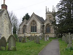
 St Mary's Church |
|
| Timsbury shown within Somerset | |
| Population | 2,624 in 2011 |
| OS grid reference | ST669587 |
| Unitary authority | |
| Ceremonial county | |
| Region | |
| Country | England |
| Sovereign state | United Kingdom |
| Post town | BATH |
| Postcode district | BA2 |
| Dialling code | 01761 |
| Police | Avon and Somerset |
| Fire | Avon |
| Ambulance | South Western |
| EU Parliament | South West England |
| UK Parliament | |
Timsbury is a village and civil parish in the Bath and North East Somerset unitary authority of the county of Somerset, 8 miles (13 km) south-west of Bath England. The parish, which includes the hamlets of Meadgate, Radford and Wall Mead, has a population of 2,624.
The village has been known as Timfborough, Tymmersbarue, Timsbarrow (meaning Timbered grove), Timsbyre (wooded hillside) and Temsbury throughout its long history.
Timsbury has been a settlement since the Bronze Age. Some of the earliest written records show an entry in the Norman Domesday Book of 1086.
"Williams holds Timsbury from the Bishop of Coutance. Ape held it before 1066. It paid tax for 3 hides, land for 3 ploughs, in lordship, 1 plough, 2 slaves, one and one half hides, 2 villagers and 1 smallholder with 1 plough and one and one half hides, 2 parts of a mill which pays two shillings, meadow 26 acres. Pasture as well, 1 cob, 9 cattle, 14 pigs and 60 sheep, the value was 26 shillings, now 50 shillings."
The entry then goes on to describe the Mill at Radford which is to the south of the village.
The parish was part of the hundred of Chew.
Timsbury House was a large mansion house owned by the Samborne family. Built towards the end of the 15th century by Richard Samborne. His successor Barnaby Samborne was knighted for his services to Queen Elizabeth I. The building was demolished in 1961, and St. Marys Green and Somerset Folly estates now occupy the original site. One unusual feature of the estate was the presence of a ha-ha (sunken path). This was constructed to allow the Samborne family privacy from the local inhabitants as they passed the house.
Pitfour House in the High street was built in the mid 17th century. The terrace of houses at Crook Barton dates back to around 1700.
In 1795, the Gooseyard bridge in Timsbury parish was the starting point for the Somerset Coal Canal which served the seven coal mines at Amesbury, Mearns, Tyning, Hayeswood, Old Grove, and Upper and Lower Conygre, around the village which formed a major part of the Somerset Coalfield. Lower Conygre (Conigre in some old spellings) was sunk in 1847 and in 1896 was merged with the older Upper Congyre which had been started in 1791. They were owned by Samborne Smith and Company in 1908, and then by Beaumont, Kennedy and Co. The Amesbury pit opened before 1701 and closed in the early 19th century. Hayeswood colliery opened in 1750 and closed in 1862. Tyning opened in 1766 followed by Mearns which was sunk in 1783 and closed in 1824.
...
Wikipedia

