Tillicoultry
Tillicoultry
|
|
|---|---|
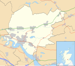
| Tillicoultry shown within Clackmannanshire | |
| Population | 5,221 |
| OS grid reference | NS9180696986 |
| Council area | |
| Lieutenancy area | |
| Country | Scotland |
| Sovereign state | United Kingdom |
| Post town | Tillicoultry |
| Postcode district | FK13 |
| Dialling code | 01259 |
| Police | Scottish |
| Fire | Scottish |
| Ambulance | Scottish |
| EU Parliament | Scotland |
| UK Parliament | |
| Scottish Parliament | |
Tillicoultry (/ˌtɪli.ˈkuːtri/ TIL-lee-COO-tree; Scottish Gaelic: Tulach Cultraidh, perhaps from older Gaelic Tullich-cul-tir, or "the mount/hill at the back of the country") is a town in Clackmannanshire, Scotland.
One of the Hillfoots Villages on the A91, which runs from Stirling to St. Andrews, Tillicoultry is situated at the southern base of the Ochil Hills, which provide a spectacular backdrop. The River Devon lies to the south. The river also runs through neighbouring villages Dollar and Alva to the east and west respectively. The former mining village of Coalsnaughton lies just south, whilst Alloa lies 4 mi southwest.
For brevity, Tillicoultry is often referred to as 'Tilly' by the locals.
The mount referred to by the name is most likely Kirkhill at the east of the town. The alternative Latin etymology, Tellus culta, the cultivated land, suggested by Rev. William Osborne, minister of the parish from 1773 to 1794, is extremely unlikely, as the prefix "tilly-" or "tullie-" can be found in a number of other Scottish names anglicised as "Tulach".
...
Wikipedia

