Tigaon, Camarines Sur
| Tigaon | |
|---|---|
| Municipality | |
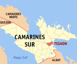
 Map of Camarines Sur showing the location of Tigaon |
|
| Location within the Philippines | |
| Coordinates: 13°38′N 123°30′E / 13.63°N 123.5°ECoordinates: 13°38′N 123°30′E / 13.63°N 123.5°E | |
| Country | Philippines |
| Region | Bicol Region (Region V) |
| Province | Camarines Sur |
| District | 4th district |
| Barangays | 23 |
| Government | |
| • Municipal Mayor | Pamela Rinah B. Fuentebella (NPC) |
| Area | |
| • Total | 72.35 km2 (27.93 sq mi) |
| Population (2015 census) | |
| • Total | 55,272 |
| • Density | 760/km2 (2,000/sq mi) |
| Time zone | PST (UTC+8) |
| ZIP code | 4420 |
| IDD : area code | +63 (0)54 |
| Income class | 3rd Class; partially urban |
| Website | www |
Tigaon is a 3rd class municipality in the province of Camarines Sur, Philippines. According to the 2015 census, it has a population of 55,272 people.
It is in the eastern part of the province of Camarines Sur, between Mount Isarog and the Lagonoy Gulf, and occupies a total land area of 12,575 ha., 80% of which is flat. Of these, 1,045 hectare are irrigated riceland.
Tigaon's economy is based on agricultural products like rice, corn, sugar cane, abaca fiber, fish, and pork. It is also known for its cottage industry, especially high quality ships-in-bottles. The main tourist attractions are the Mt. Isarog Jungle Park at Barangay Concocep and several beach resorts.
According to a certain parish priest, Fr. Marcos de Lisboa, the name of the town was attributed to the word "tigaw", a shrub grew in abundance on the river banks, and whose leaves when pounded produced extracts which were used as poison to catch fish in rivers and swamps.
The Bicol Peninsula was first sighted by the Spaniards in August 1543 aboard the San Juan de Letran. In 1574, Captain Juan de Salcedo conquered the Bicol Region. In 1701, Tigaon was considered a sitio of Sagñay. In 1794, Tigaon was given her own parish under Fray Jose de Buensalida who carried the mission of St. Clare of Assisi, marking August 12 as her feastday.
Mayon Volcano’s eruption in 1834 started a wave of migration from the neighboring province of Albay to the rich verdant slopes of Tigaon. As the Sword and the Cross became the bedrock of Spanish colonization in the Philippines, the parish priest symbolized the King of Spain and wielded immense power. This resulted in turmoil and continuous revolts against the atrocities of Spanish rule, thereby leading to the Philippine Revolution of 1898. For $20,000,000.00, Spain ceded the Philippines to the Americans.
In the early years of the 19th century, Camarines Sur was divided into four districts by the Spaniards. This division include the districts of Bikol, Rinconanda, Yraya and Mambulao. The mission of Tigaon in the part of Mount Isarog belonged to the Bikol district. The history of this town, according to written accounts, was considered to be confusing as there are conflicting records with regards to its establishment as a municipality.
...
Wikipedia

