Thukela
| Tugela | |
| Thukela | |
| River | |
|
The Tugela River with the Amphitheatre in the background
|
|
| Country | South Africa |
|---|---|
| Province | KwaZulu-Natal |
| Towns | Bergville, Colenso |
| Landmarks | Tugela Falls, Fort Tenedos |
| Source | |
| - location | Drakensberg |
| Mouth | Indian Ocean |
| Length | 502 km (312 mi) |
| Basin | 29,100 km2 (11,236 sq mi) |
|
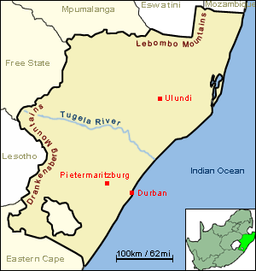
The course of the Tugela river, from the west to the east border of KwaZulu-Natal.
|
|
The Tugela River (Zulu: Thukela; Afrikaans: Tugelarivier) is the largest river in KwaZulu-Natal Province, South Africa. It is one of the most important rivers of the country.
The river originates in Mont-aux-Sources of the Drakensberg Mountains and plunges 947 metres down the Tugela Falls. The Mont-aux-Sources is also the origin of tributaries of two other major South African rivers, the Orange and the Vaal. From the Drakensberg range, the Tugela follows a 502 kilometres (312 mi) route through the KwaZulu-Natal midlands before flowing into the Indian Ocean. The total catchment area is approximately 29,100 square kilometres (11,200 sq mi). Land uses in the catchment are mainly rural subsistence farming and commercial forestry.
Minion created The Tugela has a number of tributaries coming off the Drakensberg, the largest being the Mzinyathi ("Buffalo") River (rising near Majuba Hill), but also the Little Tugela River, Klip River (rising near Van Reenen Pass), Mooi River, Blood River, Sundays River (rising in the Biggarsberg) Ingagani River and Bushman River. The Buffalo River joins the Tugela some 19 kilometres (12 mi) east of Tugela Ferry at 28°43′04″S 30°38′41″E / 28.71778°S 30.64472°E.
...
Wikipedia


