Thokoza
|
Thokoza Menoldin |
|
|---|---|

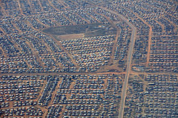
Aerial view of Thokoza
|
|
|
|
|
| Coordinates: 26°20′12″S 28°08′48″E / 26.33667°S 28.14667°ECoordinates: 26°20′12″S 28°08′48″E / 26.33667°S 28.14667°E | |
| Country | South Africa |
| Province | Gauteng |
| Municipality | Ekurhuleni |
| Established | 1973 |
| Government | |
| • Councillor | Stan Gettr |
| Area | |
| • Total | 9.43 km2 (3.64 sq mi) |
| Population (2011) | |
| • Total | 105,827 |
| • Density | 11,000/km2 (29,000/sq mi) |
| Racial makeup (2011) | |
| • Black African | 99.1% |
| • Coloured | 0.4% |
| • Indian/Asian | 0.1% |
| • White | 0.1% |
| • Other | 0.2% |
| First languages (2011) | |
| • Zulu | 40.2% |
| • Sotho | 21.5% |
| • Xhosa | 18.4% |
| • Northern Sotho | 5.4% |
| • Other | 14.5% |
| Postal code (street) | 1426 |
| PO box | 1421 |
Thokoza is a township south of Johannesburg, South Africa at the location of the now defunct Palmietfontein Airport. It is situated south east of Alberton, adjacent to Katlehong on the East Rand, Gauteng, South Africa. Thokoza is the first black township which was established in the East Rand. During the early 1990s Thokoza was the middle of a civil war between the supporters of the Inkatha Freedom Party (IFP), rival party of the African National Congress (ANC).
In 1955, the Germiston and Alberton municipalities swapped land and the latter received part of the land that made up the Natalspruit area, which was needed to form a new black township. From 1958-59, the Alberton municipality begun to develop a new township on the Palmietfontein section. Each plot was to be serviced with a basic water and sewerage infrastructure, with the building of a one bedroom shack and later one, two or three bedroom houses. The new township would be called Thokoza (place of peace). By 1961 all black residents of locations within the Alberton municipality had been moved to the new township after a registration process and the issuing of plot locations.
All this was in aid of carrying out the introduction of the Apartheid governments Native (Urban Areas) Consolidation Act, which controlled the movement of the black population in the country to certain areas of work and residence. Financially, municipalities were aided in this process by the enactment of two new laws in the 1950s. Bantu Building Workers' Act (1950) which allowed black workers, on low wages, to build the houses and infrastructure and the Bantu Services Levy Act (1952) which paid for the new building work by levying the wages of black employees in the country.
From 1961 until 1981, three hostels, Madala, Buyafuthi and Umshayzafe were constructed for migrant labour and situated along Khumalo Road, the main road in the city which stretches for over seven kilometers. Khumalo Street would be named after Jacon Khumalo, a migrant worker from Vryheid, KwaZulu-Natal and who was a community leader in 1960s and who's house is still found along the road. The hostels were created for 2500 men but by the 1980s the popolutation residing in them had risen to as high as 13,000 split along ethnic, social and language groups. This tended to isolated the hostel dwellers from the township dwellers and led to tension in later years. By the late 1960s, crime levels grew in the region as social conditions deteriorated and employment dropped.
...
Wikipedia


