Thirunelveli
|
Tirunelveli Nellai |
|
|---|---|
| city | |

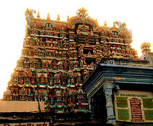
Nellaippar temple tower
|
|
| Coordinates: 8°44′N 77°42′E / 8.73°N 77.7°ECoordinates: 8°44′N 77°42′E / 8.73°N 77.7°E | |
| Country | India |
| State | Tamil Nadu |
| District | Tirunelveli |
| Government | |
| • Body | Tirunelveli City Municipal Corporation |
| • Mayor | E. Bhuvaneswari |
| Area | |
| • city | 169.9 km2 (65.6 sq mi) |
| Area rank | 5 |
| Elevation | 47 m (154 ft) |
| Population (2011) | |
| • city | 1,473,637 |
| • Density | 4,370/km2 (11,300/sq mi) |
| • Metro | 1,518,984 |
| Demonym(s) | Tirunelvelian, Tirunelveli Karan |
| Languages | |
| • Official | Tamil |
| Time zone | IST (UTC+5:30) |
| PIN | 627xxx |
| Telephone code | 91 (0)462 |
| Vehicle registration | TN-72 (Tirunelveli city) ,TN-76 (Tenkasi Region) ,TN-79 (Sankarankoil Region) |
| Website | nellai |
Tirunelveli ![]() pronunciation ), also known as Nellai and historically (during British rule) as Tinnevelly, is a city in the South Indian state of Tamil Nadu. It is the administrative headquarters of the Tirunelveli District. It is the sixth-largest municipal corporation in the state (after Chennai, Madurai, Coimbatore, Tiruchirappalli, Salem). Tirunelveli is located 624 km (388 mi) southwest of the state capital, Chennai and 48 km (30 mi) away from Thoothukudi.
pronunciation ), also known as Nellai and historically (during British rule) as Tinnevelly, is a city in the South Indian state of Tamil Nadu. It is the administrative headquarters of the Tirunelveli District. It is the sixth-largest municipal corporation in the state (after Chennai, Madurai, Coimbatore, Tiruchirappalli, Salem). Tirunelveli is located 624 km (388 mi) southwest of the state capital, Chennai and 48 km (30 mi) away from Thoothukudi.
The city is located on the west bank of the Thamirabarani River; its twin city Palayamkottai is on the east bank. Tirunelveli is believed to be an ancient settlement; it has been ruled at different times by the Early Pandyas, the Medieval and Later Cholas, the later Pandyas, the Ma'bar and Tirunelveli sultanates, the Vijayanagar Empire, the Madurai Nayaks, Chanda Sahib, the Carnatic kingdom and the British. The Polygar War, involving Palaiyakkarars led by Veerapandiya Kattabomman and forces of the British East India Company, was waged on the city's outskirts from 1797 to 1801. Tirunelveli has a number of historical monuments, the Nellaiappar Temple being the most prominent.
...
Wikipedia

