Theunissen
| Theunissen | |
|---|---|

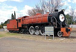
SAR Class 16DA no. 850 plinthed in Theunissen
29 May 2005 |
|
|
|
|
| Coordinates: 28°24′0″S 26°43′0″E / 28.40000°S 26.71667°ECoordinates: 28°24′0″S 26°43′0″E / 28.40000°S 26.71667°E | |
| Country | South Africa |
| Province | Free State |
| District | Lejweleputswa |
| Municipality | Masilonyana |
| Established | 13 September 1907 |
| Area | |
| • Total | 13.9 km2 (5.4 sq mi) |
| Population (2011) | |
| • Total | 23,512 |
| • Density | 1,700/km2 (4,400/sq mi) |
| Racial makeup (2011) | |
| • Black African | 94.6% |
| • Coloured | 0.6% |
| • Indian/Asian | 0.4% |
| • White | 4.1% |
| • Other | 0.3% |
| First languages (2011) | |
| • Sotho | 72.8% |
| • Xhosa | 12.7% |
| • Afrikaans | 6.1% |
| • Tswana | 2.9% |
| • Other | 5.5% |
| Postal code (street) | 9410 |
| PO box | 9410 |
| Area code | 057 |
Theunissen is a small town that has the only wine estate, the Theunissen Wine Farm, in the Free State province of South Africa. It was founded by Boer War Commandant Helgaardt Theunissen. Theunissen has a small community (mostly farmers and miners) which supports the local businesses.
The founding of Theunissen and its history goes hand in hand with the development of the railway system in the Orange Free State (OFS). When gold was discovered in the Witwatersrand, railways to the new gold fields were a necessity. During this period there were no railways in the OFS and the Transvaal. The nearest railway lines were Kimberley and Pietermaritzburg. Connecting to the coastal ports from the Witwatersrand was vital. A race started from the Natal and Cape coastal ports to connect with the gold fields. In 1887 the Cape government received a concession from the OFS government to build a railway line through the OFS. This railway line was completed in sections which were opened on the following dates:
The line reached the Witwatersrand during the same year. Smaldeel station was erected directly to the west of Winburg. Because Winburg, the oldest town in the Free State, was not connected with the main railway line, the residents insisted that the OFS Government had to build a railway line from Winburg to Smaldeel. After careful consideration, the Government decided that a railway line will be built through Winburg to Clocolan. The line from Smaldeel to Winburg was opened on 1 November 1898. The building of the line to Clocolan was in an advanced stage when the Second Anglo-Boer War broke out. The line, to date, has not been completed.
Smaldeel grew rapidly, as it was the junction where the main line from Bloemfontein and the line from Winburg, Clocolan, Ficksburg and Ladybrand, met. The residents of the Smaldeel station and the farmers from the region decided that the time has come to apply for the establishment of a township. There were objections to the establishment of a town. On the one hand there were the settlers at the railway station and the farmers in the region who wanted to see the establishment of a town. They were represented by Helgaardt Theunissen who, from the beginning, put all his weight behind the campaign for the establishment of a town. On the other hand, were the residents of the Winburg district, who believed that the establishment of a township in the vicinity would greatly hamper trade in their town, especially with the recent establishment of the nearby towns such as Senekal, Ventersburg and Marquard. The result was the submission of two requisitions to the Legislative Council of the OFS:
...
Wikipedia


