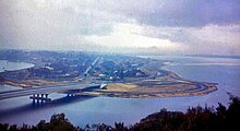
The Narrows, Western Australia
| Narrows Bridge Southbound |
|
|---|---|

The bridge viewed from Kings Park, circa 1959
|
|
| Coordinates | 31°57′48″S 115°50′49″E / 31.96333°S 115.84694°ECoordinates: 31°57′48″S 115°50′49″E / 31.96333°S 115.84694°E |
| Carries |
Kwinana Freeway (southbound road lanes) |
| Crosses | Swan River |
| Maintained by | Main Roads Western Australia |
| Heritage status | WA Heritage Register |
| Characteristics | |
| Material | Reinforced concrete |
| Total length | 396.5 m (1,301 ft) |
| Width | 27.4 m (90 ft) |
| Longest span | 320 ft (98 m) |
| No. of spans | 5 |
| Piers in water | 2 |
| History | |
| Designer | Sir William Holford |
| Construction start | 8 June 1957 |
| Opened | 13 November 1959 |
| Narrows Bridge Northbound |
|
|---|---|

The duplicate bridge seen here in the foreground, with the darker road surface.
|
|
| Carries |
Kwinana Freeway (northbound road lanes); Northbound railway line |
| Crosses | Swan River |
| Maintained by | Main Roads Western Australia |
| Narrows Rail Bridge | |
|---|---|
| Carries | Southbound railway line |
| Crosses | Swan River |
| Characteristics | |
| No. of spans | 5 |
| Piers in water | 2 |
| History | |
| Opened | 23 December 2007 |
The Narrows Bridge is a freeway crossing of the Swan River in Perth, Western Australia.
Made up of two road bridges and a railway bridge located over a section of water known as The Narrows, located between Mill Point and Point Lewis, it connects the Mitchell and Kwinana Freeways, linking the city's northern and southern suburbs. The original road bridge was opened in 1959 and was the largest precast prestressed concrete bridge in the world. Construction of the northern interchange for this bridge necessitated the reclamation of a large amount of land from the river.
The bridge formed part of the Kwinana Freeway which originally ran for only 2.4 miles (3.9 km). Over the following decades, the freeway system was expanded to the north and south, greatly increasing the volume of traffic using the bridge. As a result, in 2001, a duplicate traffic bridge was opened to the west of the original bridge, and in 2005, the railway bridge was constructed in the gap between the two traffic bridges. Passenger trains first traversed the Narrows in 2007 with the opening of the Mandurah railway line.
The close distance between Mill Point and Point Lewis at the foot of Mount Eliza meant the site was suggested as a suitable location for a bridge as early as 1849. A bridge was proposed for the site in 1899, but its expected cost of £13,000 was deemed too high. Preliminary planning for a bridge at the site finally began in 1947, but was suspended so that a replacement, The Causeway, could be built at Heirisson Island, at the city's eastern end. The new Causeway bridges were opened in 1952, and by 1954 traffic using them to enter the city had doubled, renewing calls for a bridge at The Narrows.
Site investigations for the bridge began in August 1954. The bridge was proposed for The Narrows site by the Town Planning Commission under the chairmanship of Harold Boas. The chosen site drew public protest on the basis that the bridge would spoil the view to and from the city. Also, residents of the wealthy Mill Point area were angry that they would have a major highway running beside their houses. The site also necessitated the reclamation of 60 acres (24 ha) of land from Mounts Bay for the bridge approach and interchange. This land reclamation, which started in October 1954, saw the addition of 4,500,000 cubic yards (3,400,000 m3) of sand, much of which was dredged from Melville Water.
...
Wikipedia
