The Mall (Washington, DC)
|
National Mall
|
|

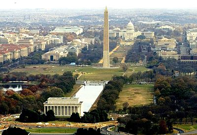
2005 aerial view facing east from above the Potomac River
|
|
| Location | Between Independence and Constitution Avenues from the Capitol to the Lincoln Memorial |
|---|---|
| Coordinates | 38°53′24″N 77°1′25″W / 38.89000°N 77.02361°WCoordinates: 38°53′24″N 77°1′25″W / 38.89000°N 77.02361°W |
| Architect | Pierre (Peter) Charles L'Enfant; McMillan Commission |
| Website | National Mall and Memorial Parks |
| NRHP Reference # |
66000031 (original) 16000805 (increase) |
| Significant dates | |
| Added to NRHP | October 15, 1966 |
| Boundary increase | December 8, 2016 |
The National Mall is a national park in downtown Washington, D.C., the capital of the United States. The National Park Service (NPS) administers the National Mall, which is part of its National Mall and Memorial Parks unit. The term National Mall commonly includes areas that are officially part of West Potomac Park and Constitution Gardens to the west, and often is taken to refer to the entire area between the Lincoln Memorial and the United States Capitol, with the Washington Monument dividing the area slightly west of its midpoint. A smaller designation, sometimes referred to as the Mall proper, excludes both the Capitol grounds and the Washington Monument grounds, applying only to an area between them. The National Mall contains a number of museums and memorials and receives approximately 24 million visitors each year.
In his 1791 plan for the future city of Washington, D.C., Pierre (Peter) Charles L'Enfant envisioned a garden-lined "grand avenue" approximately 1 mile (1.6 km) in length and 400 feet (120 m) wide, in an area that would lie between the Capitol building and an equestrian statue of George Washington to be placed directly south of the White House (see L'Enfant Plan). The National Mall occupies the site of this planned "grand avenue", which was never constructed. The Washington Monument stands near the planned site of its namesake's equestrian statue. Mathew Carey's 1802 map is reported to be the first to name the area west of the United States Capitol as the "Mall".
...
Wikipedia

