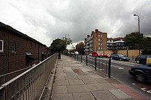
The Highway

The Highway near the junction of Garnet Street
|
|
| Former name(s) | Ratcliffe Highway |
|---|---|
| Length | 1.4 mi (2.3 km) |
| Location | London Borough of Tower Hamlets, United Kingdom |
| Postal code | E1 |
| West end | Tower Hill |
| East end | Limehouse |
| Other | |
| Known for | Ratcliff Highway murders |
Coordinates: 51°30′35″N 0°03′28″W / 51.5097°N 0.0579°W
The Highway, formerly known as the Ratcliffe Highway, is a road in the East End of London.
The route dates back to Roman times. In the 19th century it had a notorious reputation for vice and crime and was the location of the infamous Ratcliff Highway murders. The name 'Ratcliffe' literally means 'red cliff', referring to the red sandstone cliffs which descended from the plateau on which the road was situated down to the Wapping Marshes to the south.
The Highway runs west-east from the eastern edge of London's financial district, the City of London, to Limehouse. It runs parallel to and south of Commercial Road, the Docklands Light Railway and Cable Street. It connects East Smithfield and the Limehouse Link tunnel.
The road forms an unofficial boundary of Wapping, which lies between the River Thames and The Highway. It is also close to Shadwell Basin to the southeast, Tower Hill to the west, and Whitechapel and Stepney to the north.
...
Wikipedia
