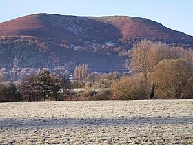
The Blorenge
| Blorenge | |
|---|---|

Blorenge from Abergavenny
|
|
| Highest point | |
| Elevation | 561 m (1,841 ft) |
| Prominence | 134 m (440 ft) |
| Parent peak | Coity Mountain |
| Listing | Dewey, HuMP |
| Geography | |
| Location | Monmouthshire, Wales |
| Parent range | Brecon Beacons |
| OS grid | SO269118 |
| Topo map | OS Landranger 161 |
Blorenge or sometimes The Blorenge (/ˈblɒrᵻndʒ/; Welsh: Blorens) is a prominent hill overlooking the valley of the River Usk in Monmouthshire, southeast Wales. It is situated in the southeastern corner of the Brecon Beacons National Park. The summit plateau reaches a height of 1,841 feet (561 m).
Blorenge overlooks the market town of Abergavenny and the villages of Llanfoist and Govilon in the Usk Valley to the north. At the foot of the mountain lies the Monmouthshire & Brecon Canal. It drops away steeply to the northwest into Cwm Llanwenarth. To the south, gentler slopes fall away to Blaenavon at the head of the Lwyd valley. Prominent peaks seen from the Blorenge include the Skirrid to the east of Abergavenny and the Sugar Loaf to the north.
Blorenge is composed in layer-cake fashion of a number of different rock types. Its lower slopes are formed from the sandstones and mudstones deposited during the Devonian period and known collectively as the Old Red Sandstone. Its higher reaches are formed from a suite of mudstones, limestones and sandstones of Carboniferous age. The summit plateau is formed from coarse sandstones that lie at the boundary of the Millstone Grit and the Coal Measures. All of these beds tilt south-westwards into the South Wales Coalfield basin.
...
Wikipedia
