Thanon Thongchai Range
| Thanon Thong Chai Range Thanon Range / Tanen Taunggyi |
|
|---|---|
| เทือกเขาถนนธงชัย | |

The east side of the eastern Thanon Thong Chai Range rising above Chiang Mai airport
|
|
| Highest point | |
| Peak | Doi Inthanon |
| Elevation | 2,565 m (8,415 ft) |
| Coordinates | 18°35′16″N 98°29′13″E / 18.58778°N 98.48694°ECoordinates: 18°35′16″N 98°29′13″E / 18.58778°N 98.48694°E |
| Dimensions | |
| Length | 170 km (110 mi) N/S |
| Width | 80 km (50 mi) E/W |
| Geography | |

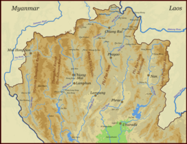
Map of the Thai highlands
|
|
| Country | Thailand |
| States/Provinces | Chiang Mai Province, Mae Hong Son Province and Lamphun Province |
| Parent range | Shan Hills |
| Geology | |
| Age of rock | Precambrian |
| Type of rock | Granite and limestone |
The Thanon Thong Chai Range (Thai: เทือกเขาถนนธงชัย, formerly Thanon Range; Burmese Tanen Taunggyi) is a mountain range in northern Thailand. Its tallest peak is Doi Inthanon, the highest point in Thailand. Most of the range is located in Chiang Mai Province, with parts in Mae Hong Son and Lamphun Provinces.
Geologically in the Thanon Thong Chai Range, as in the other southern subranges of the Shan Hills, layers of alluvium are superimposed on hard rock. Precambrian rocks are present in this range, but absent in the ranges further east, such as the Khun Tan Range.
The Thanon Thong Chai Range is the southernmost prolongation of the Shan Hills and it consists of two parallel ranges running southwards from the southwestern limits of the Daen Lao Range between rivers Yuam and Ping. The eastern range is also known as Inthanon Range (ทิวเขาอินทนนท์). Often the Dawna Range further west and south is included as the western part of the Thanon Thong Chai Range. There are also some geographers who include the Thanon Thong Chai as a subrange of the Daen Lao Range.
Doi Inthanon, at 2,565 metres in the Inthanon Range, is one of the ultra prominent peaks of Southeast Asia. Other high peaks of the Thanon Thong Chai Range are 2,340 m high Doi Hua Mot Luang, the second highest peak in Thailand, Doi Pui (1,685 m), and 1,676 m high Doi Suthep.
Certain hill tribe communities live in the range, like the Hmong and the Karen whose tribal villages dot the mountainsides. Some of these communities are regularly visited by organized tourist groups.
...
Wikipedia
