Tentsmuir Forest
| Tentsmuir Forest National Nature Reserve | |
|---|---|
 |
|
| Location | Fife, Scotland |
| Coordinates | 56°25′N 2°50′W / 56.42°N 2.83°WCoordinates: 56°25′N 2°50′W / 56.42°N 2.83°W |
| Area | 50 square miles (130 km2) |
| Governing body | Scottish Natural Heritage (SNH), RSPB |
| Tentsmuir Forest | |
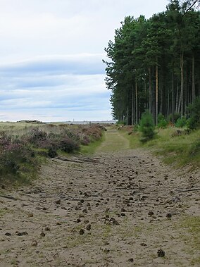
Tentsmuir Forest is in north east Fife, Scotland. Covering some 50 square miles (130 km2), the forest was originally sand dunes and moorland before acquisition by the Forestry Commission in the 1920s. The forest consists mainly of Scots pine and Corsican pine.Forestry Commission Scotland still owns the forest.
Tentsmuir is a key geomorphological site for the study of active beach and coastal processes, in particular those associated with coastal progradation (shoreline building out seawards). The site supports an extensive and relatively undisturbed area of intertidal sand, mudflats and rapidly accreting lime-poor dunes. There are complete sequences of sand dune and slack communities from strandline, saltmarsh, accreting “yellow” dunes, fixed “grey dunes” to lichen rich dune heath, dune slack and dune slack woodland. Associated with these habitats are a large number of plant and invertebrate species including many of national or regional importance. The intertidal flats regularly support large concentrations of passage or wintering waterfowl and waders. Three species have been recorded at nationally important numbers (between 2004 and 2009). There were eider (11.45% of the UK population), bar-tailed godwit (1.93%) and goosander (1.04%). The outer sandflats are also a haul-out site for both common and grey seals. (SNH Site of Special Scientific Interest Site Management Statement)
Tentsmuir is notable for the many concrete blocks known as 'Dragon's Teeth' distributed along the shoreline, which acted as coastal defence against landing craft during World War II. The nearby RAF Leuchars base means that military aircraft are often seen (and heard), but aviation links go back to 1911 with the setting up of a Royal Engineers training camp. During World War II troops of the Polish Army were based here to staff the coastal defences.
Also of interest is a 19th-century icehouse, historically used to store salmon but now an important artificial bat roost.
...
Wikipedia

