Tenerife Island
| Tenerife | ||
|---|---|---|
| Island | ||

Clockwise from top: Dracaena draco, Roques de Anaga, Teide National Park, Traditional Canarian house and Auditorio de Tenerife.
|
||
|
||
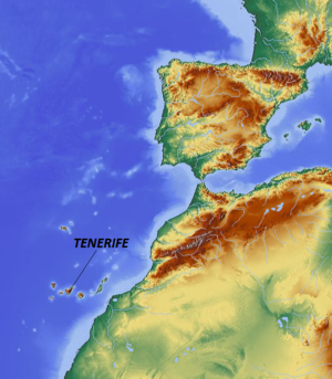
 Map showing location of Tenerife |
||
| Coordinates: 28°16′7″N 16°36′20″W / 28.26861°N 16.60556°WCoordinates: 28°16′7″N 16°36′20″W / 28.26861°N 16.60556°W | ||
| Country | Spain | |
| Autonomous community | Canary Islands | |
| Province | Santa Cruz de Tenerife | |
| Capital and Largest City |
|
|
| Area | ||
| • Total | 2,034 km2 (785 sq mi) | |
| Highest elevation (Teide) | 3,718 m (12,198 ft) | |
| Population (2014) | ||
| • Total | 889,936 | |
| • Density | 442/km2 (1,140/sq mi) | |
| • Ethnicities | Spanish, other minority groups | |
| Time zone | UTC (UTC0) | |
| • Summer (DST) | UTC+1 (UTC+1) | |
| Website | www.tenerife.es | |
| Buenavista del Norte | ||||||||||||||||||||||||||||||||||||||||||||||||||||||||||||
|---|---|---|---|---|---|---|---|---|---|---|---|---|---|---|---|---|---|---|---|---|---|---|---|---|---|---|---|---|---|---|---|---|---|---|---|---|---|---|---|---|---|---|---|---|---|---|---|---|---|---|---|---|---|---|---|---|---|---|---|---|
| Climate chart () | ||||||||||||||||||||||||||||||||||||||||||||||||||||||||||||
|
||||||||||||||||||||||||||||||||||||||||||||||||||||||||||||
|
||||||||||||||||||||||||||||||||||||||||||||||||||||||||||||
| J | F | M | A | M | J | J | A | S | O | N | D |
|
167
17
12
|
95
17
11
|
70
17
12
|
18
17
12
|
12
19
13
|
9
20
14
|
1
22
17
|
3
23
18
|
4
23
17
|
90
21
16
|
207
19
15
|
122
17
13
|
| Average max. and min. temperatures in °C | |||||||||||
| Precipitation totals in mm | |||||||||||
| Source: | |||||||||||
| Imperial conversion | |||||||||||
|---|---|---|---|---|---|---|---|---|---|---|---|
| J | F | M | A | M | J | J | A | S | O | N | D |
|
6.6
63
54
|
3.7
63
52
|
2.8
63
54
|
0.7
63
54
|
0.5
66
55
|
0.4
68
57
|
0
72
63
|
0.1
73
64
|
0.2
73
63
|
3.5
70
61
|
8.1
66
59
|
Wikipedia
...
|

