Tenasserim River
| Great Tenasserim River | |
|---|---|

Great Tenasserim River
|
|
 |
|
| Country | Burma |
| Basin features | |
| River mouth | Myeik (Mergui), Andaman Sea |
| Tributaries | |
| Physical characteristics | |
| Length | 300 kilometres (190 mi) |
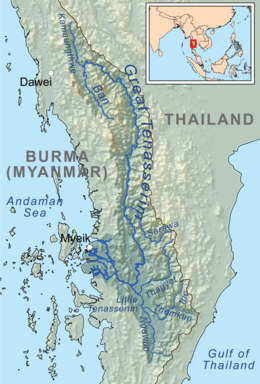
Great Tenasserim River or the Tanintharyi River is a major river of southeastern Burma. It flows through the Tanintharyi Region, past the town of Tanintharyi before entering the sea at Myeik (Mergui). The river rises from the Tenasserim Range at an altitude of 2,074 m (6,804 ft) and flows into the Andaman Sea. The region formed by this river is also known as Tenasserim, Tanintharyi in Burmese, which is in a constricted coastal region in southeastern Myanmar (formerly Burma), which has border with Thailand on the east and the Andaman Sea on the west.
While non-indigenous fruit trees and other traces of a large population that once occupied the river banks are evident, the ethnic groups who live in this river valley are the Karens in the west and north, Thais in the south, and Burmans who speak a distinct dialect of Burmese.
The Great Tenasserim River is one of the major rivers of southeastern Burma, and the most substantial running through the Tanintharyi Region. The river is formed at the confluence of rivers Kamaungthwe and Ban near Myitta. River Kamaungthwe rises in the Tenasserim Range at a height of 2,074 m (6,804 ft) and the Ban flows from the south. The Myitta River, one of its main northern tributaries joins the Tenasserim from the right northwest of Myitta town. After passing by several towns, including Tagu, Banlaw, Wunna, Thamihla, as well as the right bank towns of Tharapon and Kahan, it reaches Tanintharyi (Tenasserim).
Tanintharyi, the capital of the province, is located on the southern bank of the Great Tenasserim where it is joined by the Little Tenasserim River. From here, it flows 33 mi (53 km) before reaching the Andaman Sea at the major seaside town of Myeik (Mergui), situated on a small island that is formed by two branches of the river. These branches constitute the two largest mouths of the Great Tenasserim; there are several. Myeik is located on the island's peninsula that projects into the Andaman Sea. The river's arrival at the Andaman Sea is 150 mi (240 km) to the south of Tavoy and about 45 mi (72 km) north of where the Lenya River enters the sea. The river delta stretches over a coast line of 20 mi (32 km) with outlet channels of which the navigable channel is 3 mi (4.8 km) south of the town of Mergui at the mouth.
...
Wikipedia
