Temora Shire
|
Temora Shire New South Wales |
|||||||||||||
|---|---|---|---|---|---|---|---|---|---|---|---|---|---|

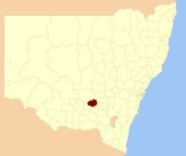
Location in NSW
|
|||||||||||||
| Population | 6,071 (2015 est) | ||||||||||||
| • Density | 2.1667/km2 (5.6116/sq mi) | ||||||||||||
| Established | 1980 | ||||||||||||
| Area | 2,802 km2 (1,081.9 sq mi) | ||||||||||||
| Mayor | Cr. Rick Firman (Unaligned) | ||||||||||||
| Council seat | Temora | ||||||||||||
| Region | Riverina | ||||||||||||
| State electorate(s) | Cootamundra | ||||||||||||
| Federal Division(s) | Riverina | ||||||||||||
 |
|||||||||||||
| Website | Temora Shire | ||||||||||||
|
|||||||||||||
Temora Shire is a local government area in the Riverina region of New South Wales, Australia. It is on Burley Griffin Way. The Shire was created on 1 January 1981 via the amalgamation of Narraburra Shire and the Municipality of Temora.
It includes the town of Temora and the small towns of Springdale, Sebastapol, Ariah Park, Gidginbung, Narraburra and Wallundry.
The mayor of Temora Shire is Cr. Rick Firman, an unaligned politician.
Temora Shire Council is composed of nine councillors elected proportionally as a single ward. All councillors are elected for a fixed four-year term of office. The mayor is elected by the councillors at the first meeting of the Council. The most recent election was held on 10 September 2016 and the makeup of the Council is as follows:
The current Council, elected in 2016, in order of election, is:
Coordinates: 34°26′S 147°32′E / 34.433°S 147.533°E
...
Wikipedia
