Tejgaon
|
Tejgaon তেজগাঁও |
|
|---|---|
| Thana | |

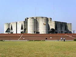
National Parliament, Dhaka, Bangladesh
|
|
| Location in Bangladesh | |
| Coordinates: 23°45.5′N 90°23.5′E / 23.7583°N 90.3917°ECoordinates: 23°45.5′N 90°23.5′E / 23.7583°N 90.3917°E | |
| Country |
|
| Division | Dhaka Division |
| District | Dhaka District |
| Area | |
| • Total | 2.74 km2 (1.06 sq mi) |
| Population (2011) | |
| • Total | 148,255 [1] |
| • Density | 25,144/km2 (65,120/sq mi) |
| Time zone | BST (UTC+6) |
| Website | bangladesh |
Tejgaon (Bengali: তেজগাঁও) is a thana of Dhaka District in the Division of Dhaka, Bangladesh. It is in the centre of Dhaka, the capital. In 2006, the boundaries of the thana were redrawn when Tejgaon Industrial Area Thana was created out of the former larger area and again in 2009 when Sher-e-Bangla Nagar Thana was created.
This is an important area of Dhaka city as the prime minister's office is here. It is bounded by Mohakhali to the north, Old Airport Road to the east and Moghbazar-Malibagh to the south and Dhanmondi to the west. It consists of several localities, including Tejgaon Industrial Area, Kawran Bazar, Nakhalpara, Shaheen Bag, Arjat para, East Raja Bazar, West Raja Bazar, Tejturi Bazar and Tejkunipara.
Tejgaon is at 23°45′30″N 90°23′30″E / 23.7583°N 90.3917°E. The total area is 2.74 km².
...
Wikipedia

