Tavurvur
| Tavurvur | |
|---|---|

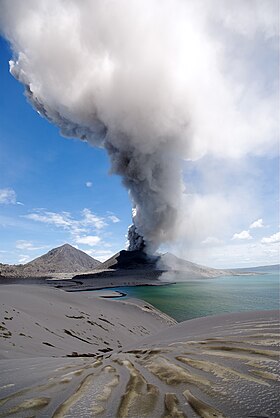
Tavurvur erupting
|
|
| Highest point | |
| Elevation | 223 m (732 ft) |
| Coordinates | 4°14′20″S 152°12′36″E / 4.239°S 152.21°ECoordinates: 4°14′20″S 152°12′36″E / 4.239°S 152.21°E |
| Geography | |
| Geology | |
| Mountain type | Cinder Cone volcano, vent of Rabaul caldera |
| Last eruption | August to September 2014 |
Tavurvur is an active stratovolcano that lies near Rabaul, on the island of New Britain, in Papua New Guinea. It is a sub-vent of the Rabaul caldera and lies on the eastern rim of the larger feature. An eruption of the volcano largely destroyed the nearby town of Rabaul in 1994.
Mount Tavurvur is the most active volcano in Rabaul caldera, and erupted most recently on 12 September 2014.
The correct pronunciation of the volcano's name is tah-VOOR-voor, according to the Rabaul Volcanological Observatory.
In 1937, Tavurvur and another nearby volcano, Vulcan, erupted, killing 508 people.
On 7 October 2006 the volcano erupted again, and an initial blast shattered windows up to 12 kilometers away and sent an ash plume 18 km into the stratosphere. Winds blew most of the ash away from Rabaul.
The latest eruption began on 29 August 2014, around 3:30–4:00 AM local time (28 August 2014, 17:30–18:00 UTC) prompting concerns over disruption of flights in Australian airspace due to the large ash clouds (up to 50,000 feet, or 15 km). Communities near the volcano were evacuated, while residents of the town of Rabaul were advised to remain indoors to avoid falling ash, according to a statement from Australia's Department of Foreign Affairs and Trade. The VEI of this eruption was 3^4.
Space Radar Image of Rabaul Volcano
Tavurvur from Low Earth orbit
Tavurvur's 2009 eruption
...
Wikipedia

