Tateyama, Chiba
|
Tateyama 館山市 |
|||
|---|---|---|---|
| City | |||

Cape Sunosaki and Tateyama City
|
|||
|
|||
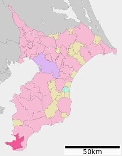
 Location of Tateyama in Chiba Prefecture |
|||
| Coordinates: 34°59′47.7″N 139°52′11.9″E / 34.996583°N 139.869972°ECoordinates: 34°59′47.7″N 139°52′11.9″E / 34.996583°N 139.869972°E | |||
| Country | Japan | ||
| Region | Kantō | ||
| Prefecture | Chiba Prefecture | ||
| Area | |||
| • Total | 110.15 km2 (42.53 sq mi) | ||
| Population (February 2016) | |||
| • Total | 47,358 | ||
| • Density | 430/km2 (1,100/sq mi) | ||
| Time zone | Japan Standard Time (UTC+9) | ||
| - Tree | Camellia | ||
| Phone number | 0470-22-3111 | ||
| Address | 1145-1 Hōjō, Tateyama-shi, Chiba-ken 294-8601 | ||
| Website | Official website | ||
Tateyama (館山市 Tateyama-shi?) is a city located in southern Chiba Prefecture, Japan. As of February, the city had an estimated population of 47,358 and a population density of 430 persons per km². The total area was 110.15 square kilometres (42.53 sq mi).
Tateyama is located at the far southern tip of the Bōsō Peninsula, facing the Pacific Ocean to the east and south, and the entrance to Tokyo Bay on the west.
Chiba Prefecture
Tateyama has a humid subtropical climate (Köppen climate classification Cfa) with very warm summers and cool winters. Precipitation is significant throughout the year, but is somewhat lower in winter.
The area of present-day Tateyama was part of ancient Awa Province, dominated by the Satomi clan during the Sengoku period, who ruled from Tateyama Castle. After the Edo period, most of the territory was part of the feudal domain of Tateyama Domain (館山藩 Tateyama-han?). After the start of the Meiji period, Tateyama Town (in Awa District), Chiba Prefecture was proclaimed on April 1, 1889. It annexed neighboring Toyosu Village on April 1, 1914, and merged with Hōjō Town to form Tateyamahōjō Town on April 18, 1933.
...
Wikipedia


