Tarczek
| Tarczek | |
|---|---|
| Village | |

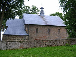
Church from the 13th century in Tarczek
|
|
| Coordinates: 50°56′35″N 21°0′12″E / 50.94306°N 21.00333°E | |
| Country |
|
| Voivodeship | Świętokrzyskie |
| County | Starachowice |
| Gmina | Pawłów |
| Population | 590 |
Tarczek [ˈtart͡ʂɛk] is a village in the administrative district of Gmina Pawłów, within Starachowice County, Świętokrzyskie Voivodeship, in south-central Poland. It lies approximately 8 kilometres (5 mi) west of Pawłów, 13 km (8 mi) south of Starachowice, and 28 km (17 mi) east of the regional capital Kielce. The village has a population of 590.
Tarczek lies on the Psarka river, among the hills of Gory Swietokrzyskie, north of Lysogory. The village is divided into two parts: Lower Tarczek (Tarczek Dolny), and Upper Tarczek (Tarczek Gorny). It has the parish church of Saint Giles. The village is located along regional road 752, which goes from Starachowice to Kielce.
In the Middle Ages, Tarczek belonged to the Bishops of Kraków, who had a manor house here, together with a church, erected in 1067 by Wladyslaw Herman, as a votum for the birth of his son Boleslaw Krzywousty. In 1227, Bishop Iwo Odrowaz, with permission of Prince of Sandomierz Leszek I the White allowed German settlers (see Ostsiedlung) to come and settle in the area of Tarczek. The village was granted Magdeburg rights in the year 1259, and was the seat of a castellan. It was a trade center of local importance, together with such towns, as Iłża and Wierzbica. In 1244, Tarczek was destroyed by Prince Konrad I of Masovia, and in 1268, it was burned in a Lithuanian raid. In the late 13th century, with permission of King Wenceslaus II of Bohemia, Tarczek was surrounded by a defensive wall.
...
Wikipedia

