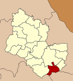
Tao Ngoi District
|
Tao Ngoi เต่างอย |
|
|---|---|
| Amphoe | |
 Amphoe location in Sakon Nakhon Province |
|
| Coordinates: 16°59′48″N 104°10′3″E / 16.99667°N 104.16750°ECoordinates: 16°59′48″N 104°10′3″E / 16.99667°N 104.16750°E | |
| Country |
|
| Province | Sakon Nakhon |
| Seat | Tao Ngoi |
| Area | |
| • Total | 328.0 km2 (126.6 sq mi) |
| Population (2005) | |
| • Total | 23,043 |
| • Density | 159.0/km2 (412/sq mi) |
| Time zone | THA (UTC+7) |
| Postal code | 47260 |
| Geocode | 4714 |
Tao Ngoi (Thai: เต่างอย, pronounced [tàw ŋɔ̄ːj]) is a district (amphoe) of Sakon Nakhon Province, northeast Thailand.
The minor district (king amphoe) was created on September 1, 1978, when the two tambon Tao Ngoi and Bueng Thawai were split off from Mueang Sakon Nakhon district. It was upgraded to a full district on July 19, 1991.
Neighboring districts are (from the west clockwise) Phu Phan, Mueang Sakon Nakhon and Khok Si Suphan of Sakon Nakhon Province, Na Kae of Nakhon Phanom Province, Dong Luang of Mukdahan Province, and Na Khu of Kalasin Province.
The district is subdivided into 4 subdistricts (tambon), which are further subdivided into 32 villages (muban). There are no municipal (thesaban) areas, and further 4 Tambon administrative organizations.
...
Wikipedia
