Tanner Trail
| Tanner Trail | |
|---|---|

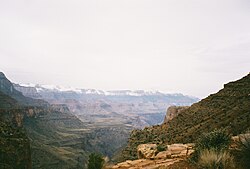
A view of Tanner Canyon
|
|
| Length | 9 mi (14 km) |
| Location | Grand Canyon National Park, Arizona, United States |
| Trailheads |
Lipan Point Colorado River Grand Canyon (South Rim) |
| Use |
Hiking Backpacking |
| Elevation | |
| Elevation change | 4,750 ft (1,450 m) |
| Highest point | Lipan Point, 7,400 ft (2,300 m) |
| Lowest point | Colorado River, 2,650 ft (810 m) |
| Hiking details | |
| Trail difficulty | Very strenuous |
| Season | Early Spring to Late Fall |
| Sights | Grand Canyon Colorado River |
| Hazards |
Severe weather Overexertion Dehydration Flash flood |
The Tanner Trail is a hiking trail located on the South Rim of the Grand Canyon National Park, located in the U.S. state of Arizona. The trailhead is located at Lipan Point, a prominent lookout located to the east of the Grand Canyon Village and it ends at the Colorado River at Tanner Rapids.
With its length, difficulty level, remoteness, and rewarding views, the Tanner Trail has become a popular destination for tourist and backpacker alike.
The Tanner Trail started out as an ancient Anasazi and Hopi route to the Colorado River. Most believe today that Tanner Canyon is where García López de Cárdenas became the first European to encounter the Grand Canyon. The trail is named after Seth Tanner, a 19th-century prospector who improved the trail so he would have better access to his copper mine. It is also believed that Tanner Canyon was once used as an old horse thief trail where buried gold known as Long Tom's treasure is located. The horse thieves would use the canyon to bring the horses from Arizona into Utah. While in the canyon, the horse thieves would change the brands of the horses, then they would cross the Colorado River and drive the horses out of the canyon through the Nankoweap Trail up onto the North Rim. The canyon was once named Horsethief Canyon in honor of this storied past.
Entrance to the South Rim of the Grand Canyon can be accessed by two points: the south entrance via State Route 64 north from Williams, and the east entrance via State Route 64 west from U.S. Route 89. The trailhead for the Tanner Trail is located near the parking area at Lipan Point, which can be accessed by the Desert View Drive. Hikers are advised to park at Lipan Point, as the trailhead is located just before the parking lot at Lipan Point.
...
Wikipedia
