Tangail District
|
Tangail টাঙ্গাইল |
|
|---|---|
| District | |
| Nickname(s): Gateway to the Central Bangladesh | |
 Location of Tangail in Bangladesh |
|
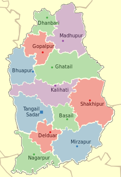
 Upazilas of Tangail |
|
| Coordinates: 24°18′N 90°00′E / 24.30°N 90.00°ECoordinates: 24°18′N 90°00′E / 24.30°N 90.00°E | |
| Country |
|
| Division | Dhaka Division |
| Area | |
| • Total | 3,414.28 km2 (1,318.26 sq mi) |
| Population (2011 census) | |
| • Total | 3,749,085 |
| • Rank | 32th in Bangladesh |
| • Density | 1,100/km2 (2,800/sq mi) |
| Literacy rate | |
| • Total | 46.8% (2011) |
| Time zone | BST (UTC+6) |
| Postal code | 1900 |
| Website | Tangail District Council website |
Tangail (Bengali: টাঙ্গাইল জেলা) is a district (zila) in the central region of Bangladesh. It is the largest district of Dhaka division by area and second largest by population (after Dhaka district). The population of Tangail zilla is about 3.8 million and its area is 3,414.28 km². The main city of the district is Tangail. It is surrounded by Jamalpur District on the north, the Dhaka and Manikganj Districts on the south, the Mymensingh and Gazipur on the east, and the Sirajganj on the west. Until 1969, Tangail was part of Mymensingh. Tangail was made a separate district in 1969[1] from Mymensingh. The main rivers that cross the Tangail district are the Jamuna, Dhaleshwari, Jhenai, Bangshi, Louhajang, Langulia, Elongjani, Jugni, Pouli, Fotikjani and the Turag.
The subdivision of Tangail was established in 1870. It was turned into a district on 1 December 1969. The district consists of 11 municipalities, 108 wards of these municipalities, 109 Union Parishads and 2516 villages.
Tangail district is subdivided into 12 Upazilas:
...
Wikipedia
