Tandridge, Surrey
| Tandridge | |
|---|---|
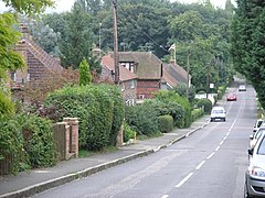
 Tandridge main street |
|
| Tandridge shown within Surrey | |
| Area | 10.99 km2 (4.24 sq mi) |
| Population | 663 (Civil Parish 2011) |
| • Density | 60/km2 (160/sq mi) |
| OS grid reference | TQ372506 |
| Civil parish |
|
| District | |
| Shire county | |
| Region | |
| Country | England |
| Sovereign state | United Kingdom |
| Post town | Oxted |
| Postcode district | RH8 |
| Dialling code | 01883 |
| Police | Surrey |
| Fire | Surrey |
| Ambulance | South East Coast |
| EU Parliament | South East England |
| UK Parliament | |
Tandridge is a village and civil parish in Surrey, England. Its nucleus is on a rise of the Greensand Ridge between Oxted and Godstone. It includes, towards its middle one named sub-locality (hamlet), Crowhurst Lane End.
In landmarks it has one of the oldest yew trees in the country, a Grade I-listed church and the tomb of the church's main benefactor Sir George Gilbert Scott's wife, Lady Scott who lived in the parish. The village is acknowledged locally for its friendly atmosphere and sense of community. There is active use of the village hall from the annual Christmas show to many parties and social events. The Village fete and Bonfire events are well attended and add to the sense of village community.
The village lay within the Anglo-Saxon Tandridge hundred.
Tandridge appears in Domesday Book of 1086 as Tenrige. It was held by the wife of Salie from Richard Fitz Gilbert. Its domesday assets were: 2 hides; 1 mill worth 4s 2d, 14 ploughs, 5 acres (2.0 ha) of meadow, woodland and herbage worth 51 hogs. It rendered £11 per year to its feudal overlords.
Variant spellings such as in feet of fines (levied by the Crown and other overlords whenever rights or lands of manors were in a significant way parted with) include Tenrige; Tanerig, Tanerigge, Tanrich, Tenrig and Tenrugge in the Middle Ages. Godstone until the 19th century cut off a detached part, Tillingdon, which lay between Godstone and Caterham and became part of the latter community.
...
Wikipedia

