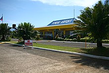
Tandag Airport
|
Tandag Airport Paliparan ng Tandag Tugpahanan sa Tandag |
|||||||||||
|---|---|---|---|---|---|---|---|---|---|---|---|
 |
|||||||||||
| Summary | |||||||||||
| Airport type | Public | ||||||||||
| Operator | Civil Aviation Authority of the Philippines | ||||||||||
| Serves | Tandag | ||||||||||
| Location | Barangay Awasian, Tandag, Surigao del Sur | ||||||||||
| Elevation AMSL | 5 m / 16 ft | ||||||||||
| Coordinates | 09°04′19.60″N 126°10′17.20″E / 9.0721111°N 126.1714444°ECoordinates: 09°04′19.60″N 126°10′17.20″E / 9.0721111°N 126.1714444°E | ||||||||||
| Runways | |||||||||||
|
|||||||||||
Tandag Airport (Filipino: Paliparan ng Tandag, Cebuano: Tugpahanan sa Tandag) (IATA: TDG, ICAO: RPMW) is the airport serving the general area of Tandag, the capital city of Surigao del Sur in the Philippines. It is one of two airports in Surigao del Sur, the other being Bislig Airport. The airport is classified as a Class 2 principal (minor domestic) airport by the Civil Aviation Authority of the Philippines, a body of the Department of Transportation and Communications that is responsible for the operations of not only this airport but also of all other airports in the Philippines except the major international airports.
...
Wikipedia
