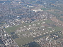
Tamiami Airport
| Miami Executive Airport | |||||||||||||||||||
|---|---|---|---|---|---|---|---|---|---|---|---|---|---|---|---|---|---|---|---|
 |
|||||||||||||||||||
| Summary | |||||||||||||||||||
| Airport type | Public | ||||||||||||||||||
| Owner | Miami-Dade County | ||||||||||||||||||
| Operator | Miami-Dade Aviation Department (MDAD) | ||||||||||||||||||
| Serves | Miami, Florida | ||||||||||||||||||
| Location | Miami-Dade County, Florida | ||||||||||||||||||
| Elevation AMSL | 8 ft / 2 m | ||||||||||||||||||
| Coordinates | 25°38′52″N 080°25′58″W / 25.64778°N 80.43278°WCoordinates: 25°38′52″N 080°25′58″W / 25.64778°N 80.43278°W | ||||||||||||||||||
| Website | www.miami-airport.com/... | ||||||||||||||||||
| Map | |||||||||||||||||||
| Location of airport in Florida / United States | |||||||||||||||||||
| Runways | |||||||||||||||||||
|
|||||||||||||||||||
| Statistics (2011) | |||||||||||||||||||
|
|||||||||||||||||||
|
Source: Federal Aviation Administration
|
|||||||||||||||||||
| Aircraft operations | 186,653 |
|---|---|
| Based aircraft | 445 |
Miami Executive Airport, formerly known until 2014 as Kendall-Tamiami Executive Airport, (IATA: TMB, ICAO: KTMB, FAA LID: TMB) is a public airport in unincorporated Miami-Dade County, Florida, 13 miles (21 km) southwest of Downtown Miami. It is operated by the Miami-Dade Aviation Department.
The airport opened on November 18th, 1967, replacing Tamiami Airport, next to the Tamiami Trail. Growth of the surrounding area and the nearby flight path to Miami International Airport had forced the move to the southwest, near the community of Kendall. Florida International University is now on the site of the old Tamiami Airport. Kendall-Tamiami airport is owned and operated by the Miami-Dade Aviation Department. 450 aircraft are based there, mostly single-engine light aircraft.
The airport is a port of entry with U.S. Customs personnel on hand, although it is not certified for airline use. In recent years it has become popular as a corporate aviation terminal.
It is the main airbase of the Miami-Dade Police Aviation Unit and houses the Miami-Dade College's aviation programs. The Wings Over Miami aviation museum is also at the field.
...
Wikipedia


