Talalora, Samar
| Talalora | |
|---|---|
| Municipality | |

Mountain-top view of Talalora
|
|
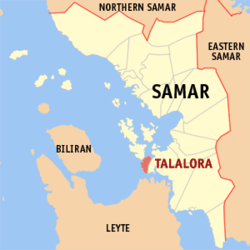
 Map of Samar with Talalora highlighted |
|
| Location within the Philippines | |
| Coordinates: 11°31′N 124°51′E / 11.517°N 124.850°ECoordinates: 11°31′N 124°51′E / 11.517°N 124.850°E | |
| Country | Philippines |
| Region | Eastern Visayas (Region VIII) |
| Province | Samar |
| District | 2nd district of Samar |
| Barangays | 11 |
| Government | |
| • Mayor | Leonilo T. Costelo |
| Area | |
| • Total | 27.96 km2 (10.80 sq mi) |
| Population (2015 census) | |
| • Total | 8,057 |
| • Density | 290/km2 (750/sq mi) |
| Time zone | PST (UTC+8) |
| ZIP code | 6704 |
| Dialing code | +63 (0)55 |
| Income class | 6th municipal income class |
| 086019000 | |
| Electorate | 6,023 voters as of 2016 |
| Website | elgu |
Talalora is a 6th class municipality in the province of Samar, Philippines. According to the 2015 census, it has a population of 8,057 people.
Talalora was created from the barrios of Mallorga, Tulac, Talalora, Tatabonan, Navatas, and Navatas Guti of the town of Villareal, by virtue of Republic Act No. 192.
Talalora is politically subdivided into 11 barangays.
...
Wikipedia

