Tahoe Park South
| Tahoe Park | |
|---|---|
| Neighborhood of Sacramento | |

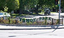
The 59th & T Street gateway to Tahoe Park
|
|
| Location within Sacramento | |
| Coordinates: 38°32′37″N 121°26′07″W / 38.543611°N 121.435278°W | |
| Country | United States |
| State | California |
| County | Sacramento |
| City | Sacramento |
| Time zone | Pacific (UTC−8) |
| • Summer (DST) | PDT (UTC−7) |
| Zip Codes | 95817 and 95820 |
Tahoe Park is a neighborhood located within the city of Sacramento, California.
The name "Tahoe Park" is generally used to refer to several official and unofficial neighborhoods that surround Tahoe Park proper, including Tahoe Park East, Tahoe Park South, Tahoe Terrace, and West Tahoe Park.
The neighborhood of Tahoe Park is centrally located in Sacramento, immediately south of U.S. Route 50 at 59th Street.
The area is less than 1-mile (1.6 km) southwest of California State University, Sacramento, less than 1-mile (1.6 km) east of the UC Davis Medical Center and approximately 4 miles (6.4 km) southeast of downtown Sacramento.
Tahoe Park is an officially recognized neighborhood in Area 3 of the City of Sacramento. It is bordered by Highway 50 and Broadway to the north, 14th Avenue to the south, 53rd and 57th Streets to the west, and 65th Street to the east.
The section of Tahoe Park that is north of Broadway is informally referred to as "Tahoe Terrace"; the name has its origins in a subdivision established in 1945.
Tahoe Park East is an officially recognized neighborhood in Area 3 of the City of Sacramento. It is bordered by 65th Street to the west, Highway 50 and the Tahoe Tallac Little League Park to the north, Business Drive to the east, and 14th Avenue to the south.
Tahoe Park South is an officially recognized neighborhood in Area 3 of the City of Sacramento. It is bordered by 14th Avenue to the north, 21st Avenue to the south, 58th Street to the west, and the 65th Street Expressway to the east.
Many long-time residents refer to Tahoe Park South as "Tallac Village"—most likely due to the presence of the Tallac Village Shopping Center on its northern boundary. However, Tallac Village is an officially recognized neighborhood immediately south of Tahoe Park South, between 21st Avenue and Fruitridge Road.
West Tahoe Park is an officially recognized neighborhood in Area 3 of the City of Sacramento. It is bordered by Broadway to the north, 14th Avenue to the south, Stockton Boulevard to the west and 53rd Street to the east.
Prior to 2005, the area west of 53rd Street was officially recognized as a part of the neighborhood of Tahoe Park proper. However, the term "West Tahoe Park" was commonly used to describe the area which, at that time, was in Sacramento's 5th district. In approximately 2005, the West Tahoe Park neighborhood was officially recognized as a separate neighborhood by the city of Sacramento. During redistricting that occurred in 2011, West Tahoe Park joined the rest of the Tahoe Park neighborhoods in District 6. By and large, this area of the Tahoe Park neighborhood is located closest to the UC Davis Medical Center.
...
Wikipedia

