Tago, Surigao del Sur
| Tago | |
|---|---|
| Municipality | |
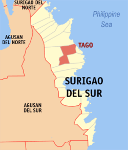
 Map of Surigao del Sur with Tago highlighted |
|
| Location within the Philippines | |
| Coordinates: 08°58′N 126°09′E / 8.967°N 126.150°ECoordinates: 08°58′N 126°09′E / 8.967°N 126.150°E | |
| Country | Philippines |
| Region | Caraga (Region XIII) |
| Province | Surigao del Sur |
| District | 1st district of Surigao del Sur |
| Founded | November 6, 1918 |
| Barangays | 24 |
| Government | |
| • Mayor | Rogelio M. Pimentel |
| Area | |
| • Total | 253.28 km2 (97.79 sq mi) |
| Population (2015 census) | |
| • Total | 35,329 |
| • Density | 140/km2 (360/sq mi) |
| Time zone | PST (UTC+8) |
| ZIP code | 8302 |
| IDD : area code | +63 (0)86 |
| Income class | 2nd municipal income class |
| 166818000 | |
| Electorate | 23,587 voters as of 2016 |
| Website | www |
Tago is a second class municipality in the province of Surigao del Sur, Philippines. According to the 2015 census, it has a population of 35,329 people.
Tago is located in the central part of Surigao del Sur facing the Pacific Ocean. It lies between 126 degrees 12 minutes longitude and 9 degrees minutes north latitude. It is bounded on the north by the Capital Town of Tandag, on the north-west by Municipality of Lanuza, on the west by Municipality of San Miguel, on the southeast by the Municipality of Bayabas and on the south by the Municipalities of Cagwait and Marihatag.
Tago sits on a 343.52 km² of land which is about 7.55% of the total area of Surigao del Sur. In terms of area, Barangay Cabangahan is the largest with 20% of Tago’s land area while Barangay Purisima is the smallest with 1.51%.
Generally, Tago falls under the normal climate with rainy season occurring from November to March and dry season from April to October. The hottest months are July and August. The planting season usually takes place in November to late January.
Tago’s soil types vary; along the shoreline is sandy. Barangays Victoria and Dayoan have Bantug clay; Barangays Gamut, Kinabigtasan, Sumo-Sumo, Adlay and Anahao Daan have Butuan clay; while Bajao, Alba, Cayale, Bangsud and Anahao Bag-o have silt loam. Matho clay can be found in most of the mountain ranges from the seashore to the boundaries of Tandag-Tago and Tago-San Miguel.
Roughly 50% of Tago’s land area is relatively flat terrain (0-3%) while roughly 30%, mostly in the north-western portion, are steep mountains.
Tago is politically subdivided into 24 barangays.
The Municipality of Tago was born thrice because of the precariousness of political times back then. It saw the light of day for the first time in 1865 under the Maura Law of the Spanish Regime that lasted for three years. Tago must have reverted to its barrio status because records had it that for the second time, it regained its municipal status on 23 August 1883, just after it transferred from the so-called Daan Lungsod (Old Town), which was perennially flooded, to the place called Laguna. When the Philippine Revolution broke out in 1896, Tago was again reverted to its barrio status.
About the middle of the First World War, the people of Tago grew politically minded and in the summer of 1916, important leaders of then Barrio of Tago like Catalino Pareja, Calixtro Espinoza, Simon Luna, Miguel Montero, Juan L. Garcia, Feleciano Arquiza, Juan Pimentel, Lorenzo Elizalde, Canuto Consuegra, Lino Montero, Isidro Garcia, Pastor Cabrera, Bernardo Falcon, Felipe Lozada and Felix Rodrigues were determined to wrestle Tago’s political independence away from the mother Municipality of Tandag.
...
Wikipedia

