Tagaytay
| Tagaytay | ||
|---|---|---|
| Component City | ||
| City of Tagaytay | ||

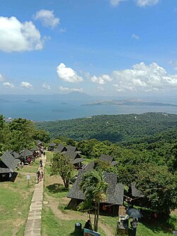
View of the Tagaytay Highlands
|
||
|
||
| Nickname(s): The Country’s 2nd Summer Capital | ||
 Map of Cavite showing the location of Tagaytay |
||
| Location within the Philippines | ||
| Coordinates: 14°06′N 120°56′E / 14.1°N 120.93°ECoordinates: 14°06′N 120°56′E / 14.1°N 120.93°E | ||
| Country | Philippines | |
| Region | CALABARZON (Region IV-A) | |
| Province | Cavite | |
| Congr. districts | 7th District of Cavite | |
| Cityhood | June 21, 1938 | |
| Barangays | 34 | |
| Government | ||
| • Mayor | Agnes Tolentino | |
| • Vice Mayor | Celso P. de Castro | |
| Area | ||
| • Total | 65.00 km2 (25.10 sq mi) | |
| Elevation | 634 m (2,080 ft) | |
| Population (2015 census) | ||
| • Total | 71,181 | |
| • Density | 1,100/km2 (2,800/sq mi) | |
| Demonym(s) | Tagaytayeño | |
| Time zone | PST (UTC+8) | |
| ZIP code | 4120 | |
| IDD : area code | +63 (0)46 | |
| Website | www |
|
Tagaytay, officially the City of Tagaytay or commonly Tagaytay City, (Filipino: Lungsod ng Tagaytay), is a component city in the province of Cavite, in the Philippines. It is one of the country's most popular tourist destinations because of its outstanding scenery and cooler climate provided by its high altitude. Tagaytay overlooks Taal Lake in Batangas and provides views of Taal Volcano Island in the middle of the lake through various vantage points situated in the city.
Tagaytay is relatively close to the capital city of Manila, only 59 kilometres (37 mi) away via Aguinaldo Highway, providing an easy escape for the locals from the heat of the huge metropolis.
Tagaytay has a total land area of 66.1 km2 (26 sq mi) which represents about 4.37% of the total area of the Province of Cavite. It lies within 120° 56' longitude and 14° 6' latitude and overlooks Manila Bay to the North, Taal Volcano and Lake to the south and Laguna de Bay to the east.
The southern and eastern portions of Tagaytay are covered by hills and mountains which is generally forests and open grasslands. The city lies along Tagaytay Ridge, a ridge stretching about 32 kilometres (20 mi) from Mount Batulao in the west to Mount Sungay (now People's Park in the Sky) in the east with elevations averaging about 610 metres (2,000 ft) above sea level. Mount Sungay, in Tagaytay, is the highest point of the province of Cavite at 709 metres (2,326 ft).
The ridge, which overlooks Taal Lake in Batangas province, is the edge of Taal Caldera. The 25-by-30-kilometre (16 mi × 19 mi) wide cavity is partially filled by Taal Lake. Tagaytay's built-up areas including the urban center is situated in the relatively level top of the caldera rim but beyond the edge are deep ravines that drop steeply to Taal Lake. The portions adjoining the municipalities of Mendez, Indang, Amadeo, Silang and Alfonso are level to nearly level areas interspersed with very gently sloping surface. Across the southern edge of the lake on the opposite side of the city is Mount Macolod, the highest point of the Taal Caldera rim.
...
Wikipedia


