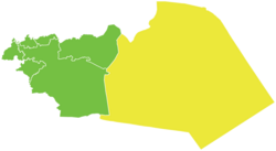
Tadmur District
|
Tadmur District منطقة تدمر |
|
|---|---|
| District | |
 Map of Tadmur District within Homs Governorate |
|
| Coordinates (Tadmur): 34°36′N 38°18′E / 34.6°N 38.3°ECoordinates: 34°36′N 38°18′E / 34.6°N 38.3°E | |
| Country |
|
| Governorate | Homs |
| Seat | Tadmur |
| Subdistricts | 7 nawāḥī |
| Area | |
| • Total | 30,823.49 km2 (11,901.02 sq mi) |
| Population (2004) | |
| • Total | 76,942 |
| • Density | 2.5/km2 (6.5/sq mi) |
| Geocode | SY0405 |
Tadmur District (Arabic: منطقة تدمر, translit. manṭiqat Tadmur) is a district of the Homs Governorate in central Syria. Administrative centre is the city of Tadmur, near ancient Palmyra/Tadmor. At the 2004 census, the district had a population of 76,942.
The district of Tadmur is divided into two sub-districts or nawāḥī (population as of 2004):
...
Wikipedia
