Tägertschi
| Tägertschi | ||
|---|---|---|
| Former municipality of Switzerland | ||
 |
||
|
||
| Coordinates: 46°52′N 7°35′E / 46.867°N 7.583°ECoordinates: 46°52′N 7°35′E / 46.867°N 7.583°E | ||
| Country | Switzerland | |
| Canton | Bern | |
| District | Bern-Mittelland | |
| Area | ||
| • Total | 3.6 km2 (1.4 sq mi) | |
| Elevation | 604 m (1,982 ft) | |
| Population (Dec 2011) | ||
| • Total | 414 | |
| • Density | 120/km2 (300/sq mi) | |
| Postal code | 3111 | |
| SFOS number | 0625 | |
| Surrounded by | Häutligen, Konolfingen, Münsingen, Wichtrach | |
| Website | SFSO statistics |
|
Tägertschi is a former municipality in the Bern-Mittelland administrative district in the canton of Bern in Switzerland. On 1 January 2017 the former municipality of Tägertschi merged into the municipality of Münsingen.
Tägertschi is first mentioned in 1273 as Tegersche.
For most of their history, the village of Tägertschi along with the settlements of Stalden and Ämligen were part of the parish and municipality of Münsingen. Eventually Ämligen and Stalden im Emmental (now part of Konolfingen) formed an independent political municipality. However, in 1923, Ämligen (which at that time had about 35 residents) voted to separate themselves from Stalden and form a new municipality with Tägertschi.
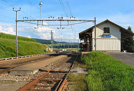
A railroad station on the Bern-Langnau was completed near Tägertschi in 1864. Today it is located on the municipal border between Tägertschi and Konolfingen. Many of the workers in the municipality commute to jobs in nearby cities, though there are several small factories in the municipality.
Tägertschi has an area of 3.64 km2 (1.41 sq mi). As of 2012, a total of 2.84 km2 (1.10 sq mi) or 78.0% is used for agricultural purposes, while 0.57 km2 (0.22 sq mi) or 15.7% is forested. Of the rest of the land, 0.19 km2 (0.073 sq mi) or 5.2% is settled (buildings or roads).
During the same year, housing and buildings made up 2.7% and transportation infrastructure made up 2.2%. Out of the forested land, all of the forested land area is covered with heavy forests. Of the agricultural land, 61.3% is used for growing crops and 12.6% is pastures, while 4.1% is used for orchards or vine crops.
The municipality is located between the Aare and Emme river valleys. It consists of the village of Tägertschi, the neighborhoods of Station and Ämligen as well as scattered farm houses.
On 31 December 2009 Amtsbezirk Konolfingen, the municipality's former district, was dissolved. On the following day, 1 January 2010, it joined the newly created Verwaltungskreis Bern-Mittelland.
...
Wikipedia


