Swall Meadows
| Swall Meadows | |
|---|---|
| Census-designated place | |

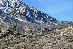
Top end of Swall Meadows (center), below the Wheeler Crest
|
|
| Location in California | |
| Coordinates: 37°30′22″N 118°38′34″W / 37.50611°N 118.64278°WCoordinates: 37°30′22″N 118°38′34″W / 37.50611°N 118.64278°W | |
| Country |
|
| State |
|
| County | Mono |
| Area | |
| • Total | 4.462 sq mi (11.556 km2) |
| • Land | 4.462 sq mi (11.556 km2) |
| • Water | 0 sq mi (0 km2) 0% |
| Elevation | 6,558 ft (1,999 m) |
| Population (2010) | |
| • Total | 220 |
| • Density | 49/sq mi (19/km2) |
| Time zone | Pacific (PST) (UTC-8) |
| • Summer (DST) | PDT (UTC-7) |
| ZIP Code | 93514 |
| Area codes | 442/760 |
| FIPS code | 06-77430 |
| GNIS feature IDs | 2583158, 2583158 |
| U.S. Geological Survey Geographic Names Information System: Swall Meadows, California | |
Swall Meadows is a census-designated place in southern Mono County, California. The community is residential, including second homes and a volunteer fire department, but no commercial development. Geographically, it sits partway up the Sherwin Grade below the Wheeler Crest of the eastern Sierra Nevada mountains, at an elevation range of approximately 6,000 to 7,000 feet (1,800 to 2,100 m). It is in pinon-juniper/subalpine zone habitat, with views south along the Sierra Crest, of Mt. Tom, and east across Owens Valley to the White Mountains toward Nevada (image, below). It is accessed from "old 395", or Lower Rock Creek Rd. Swall Meadows is located approximately 20 miles (32 km) north of Bishop and 25 miles (40 km) south of Mammoth Lakes (by highway distance). It is also well known in the area as an important deer migration route for the Round Valley Mule Deer population, which cherish the grazing in the meadow and apple falls from the old orchard trees. ZIP Code is 93514. The community is inside area code 760. The population was 220 as of the 2010 census.
According to the United States Census Bureau, the CDP covers an area of 4.5 square miles (11.6 km²), all of it land. At the high, northwestern end is the old Sky Meadows Ranch, then houses and firehouse near the meadow, and at the southeast end a development known as Pinyon Ranch.
In addition to the predominant pinyon-juniper-sagebrush habitat, there are permanent and seasonal streams and the eponymous meadow with wetter-habitat vegetation such as Jeffrey pines, willows, stream and bog orchids, and the remnant trees of the old commercial apple orchard. In 2011 the Eastern Sierra Land Trust secured a conservation easement to protect 104 acres of the Swall Meadows meadow area (location of the historic homesite), for the continued benefit of the migrating mule deer. A number of other conservation easements have been completed in Swall Meadows since the ESLT organization was founded in 2001.
...
Wikipedia

