Sutton, Kent
| Sutton | |
|---|---|
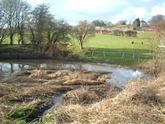
 A duck pond in Sutton |
|
| Sutton shown within Kent | |
| Population | 772 (2011) |
| OS grid reference | TR3349 |
| District | |
| Shire county | |
| Region | |
| Country | England |
| Sovereign state | United Kingdom |
| Post town | Deal |
| Postcode district | CT14 |
| Police | Kent |
| Fire | Kent |
| Ambulance | South East Coast |
| EU Parliament | South East England |
Sutton is a village and civil parish near Dover in Kent, England. In 1935 this village became a parish when the small settlements of Studdal, Sutton, Ashley, Little Mongeham and Maydensole joined to become the Parish of Sutton-by-Dover. Prior to this Sutton has had a vast history of agricultural practices, which has helped sustain the village into the parish it is today. The quoted population includes the villages of East and West Studdal plus Swingate and the hamlet of Little Mongeham.
The parish of Sutton has various recreational areas scattered throughout its settlements. Firstly, there is a "sports field located on the north side of Downs Road, which consists of a large field divided into a children's playground area, a recently constructed BMX track and a games pitch in order", appealing to Sutton's growing family community. The "allotments and community orchard, which are situated north of Chapel Lane and accessible via a path along the roadside, have been planted with traditional English apples trees, and maintained by the parish council; it has become a valued amenity". Moreover, the parish is home to some of "best footpaths in the area such as the North Downs Way, along with various picnic areas such as Jack's Bush which, situated at the peak of Downs Road, providing spectacular views across the Downs and Pegwell Bay".
Containing the only pub in the parish, the small settlement of Ashley "encompasses different stages of building development, incorporating a mixture of building styles, dating predominantly from the 1940's. Ashley's older properties are clustered in the centre of the hamlet at the intersection of the roads and paths, with one of the oldest of these being a thatched cottage. Expanding outwards from the centre, the development has grown along Waldershare Road to the West and Chapel Lane to the east", which is the main road running through this settlement.
The buildings along "Waldershare Road consist mainly of detached bungalows, which are built on both sides of the road". "The facade of the road comprises hedge and brick walls, with all the houses being located further back from the road, behind small front gardens". In comparison, the houses which run along "Chapel Lane are detached modern bungalows, which are divided with two short terraces dating from the early 1900's". In comparison to "Waldershare Road, development has only occurred on one side of the road".
The small hamlets of "Maydensole and Napchester have been founded around the farms upon which they are named after". "Great Napchester Farm, which pre-dates 1583, has undergone many alterations during the 18th and 19th century, and is now a residential farm situated in a rural setting". " Maydensole Farm was altered and extended to its present size in 1790, however since then there has been minimal alterations".
...
Wikipedia

