Sutton, Cambridgeshire
| Sutton | |
|---|---|
 |
|
| Sutton shown within Cambridgeshire | |
| Population | 196 (2011) |
| Civil parish |
|
| District | |
| Shire county | |
| Region | |
| Country | England |
| Sovereign state | United Kingdom |
| Post town | Peterborough |
| Postcode district | PE5 |
| Dialling code | 01780 |
| Police | Cambridgeshire |
| Fire | Cambridgeshire |
| Ambulance | East of England |
| EU Parliament | East of England |
Sutton is a small civil parish that is located near Peterborough, in the North-West of Cambridgeshire, England in the East Midlands. Situated 5.7 miles from Peterborough and approximately half a mile south of the A47 road.
For electoral purposes it forms part of Glinton and Wittering ward in North West Cambridgeshire constituency.
According to Office for National Statistics Sutton has a population (including Upton) of 196 with a population density of 0.2.
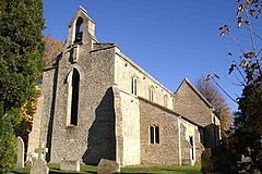
Dating all the way back to 972–992, the area of Peterborough was described as a "woody swamp" but was cleared to a certain degree when Abbot Adulf built manor houses and granges. In 'Old English', Sutton translates as a Southern farm/settlement. The ancient church of Sutton dates back to the 12th century and was originally built as a chapel-of-ease to the church of St Kyneburgha in Castor. It is also home to a war memorial. The church, now named St Michael & All Angels, was originally dedicated to Saint Giles, the patron saint of cripples, lepers and nursing mothers. The majority of the church was rebuilt in 1867–8, but the arch supports have survived from the original construction in the 12th/13th century. A grant of £37,300 was given to complete work on the church by a company called WREN in order for it to become a community hub for locals. Since the grant in 2010, the church has been improved further with such things as heating systems and carpeting.
The historical layout of the village is a simple rectangle of streets engulfing a green where cattle would be, known as a Saxon nucleated settlement (or a Nucleated village), with the grange and chapel located in one corner of the rectangle. With the village being in close proximity to the River Nene, there was once a ford going over to Stibbington, but this was eventually destroyed by dredging after a long period of not being used. The Manor Farm (also known as 'The Grange') was built in the 17th century. Keith Garrett described the manor as a "fully constituted manor with its manor house or hall, its home farm, open fields, and lands of villeins, who held their dwellings and small agricultural holdings for customary services in cultivating the Abbey's home farm etc."
...
Wikipedia

