Surtsey

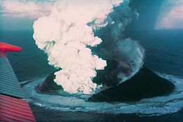
Surtsey, sixteen days after the onset of the eruption
|
|
| Map of Surtsey | |
| Geography | |
|---|---|
| Location | Atlantic Ocean |
| Archipelago | Vestmannaeyjar |
| Area | 1.4 km2 (0.54 sq mi) |
| Highest elevation | 155 m (509 ft) |
| Administration | |
|
Iceland
|
|
| Additional information | |
| Official name | Surtsey |
| Type | Natural |
| Criteria | ix |
| Designated | 2008 (32nd session) |
| Reference no. | 1267 |
| State Party | Iceland |
| Region | Europe and North America |
Surtsey ("Surtr's island" in Icelandic, pronounced /ˈsʏr̥tsei/) is a volcanic island located in the Vestmannaeyjar archipelago off the southern coast of Iceland. At 63°18′11″N 20°36′18″W / 63.303°N 20.605°WCoordinates: 63°18′11″N 20°36′18″W / 63.303°N 20.605°W, Surtsey is the southernmost point of Iceland. It was formed in a volcanic eruption which began 130 metres (426 ft) below sea level, and reached the surface on 14 November 1963. The eruption lasted until 5 June 1967, when the island reached its maximum size of 2.7 km2 (1.0 sq mi). Since then, wave erosion has caused the island to steadily diminish in size: as of 2012[update], its surface area was 1.3 km2 (0.50 sq mi). The most recent survey (2007) shows the island's maximum elevation at 155 m (509 ft) above sea level.
...
Wikipedia

