Sulphur Creek (California)
| Sulphur Creek | |
| Cañada Salada, Arroyo Salada, Laguna Niguel Lake | |
| River | |
|
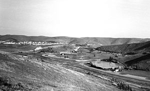
The creek and valley just below Sulphur Creek Reservoir, circa 1975
|
|
| Country | United States |
|---|---|
| State | California |
| Counties | Orange County |
| Tributaries | |
| - left | Niguel Storm Drain |
| - right | Narco Channel |
| Cities | Laguna Hills, Laguna Niguel, San Juan Capistrano |
| Source | |
| - location | Convergence of several storm drain outlets, Laguna Hills |
| - elevation | 190 ft (58 m) |
| - coordinates | 33°33′33″N 117°41′04″W / 33.55917°N 117.68444°W |
| Mouth | Aliso Creek just above the beginning of Aliso and Wood Canyons Regional Park and downstream of Laguna Niguel Regional Park |
| - location | Laguna Niguel |
| - elevation | 58 ft (18 m) |
| - coordinates | 33°32′32″N 117°42′16″W / 33.54222°N 117.70444°WCoordinates: 33°32′32″N 117°42′16″W / 33.54222°N 117.70444°W |
| Length | 4.8 mi (8 km) |
| Basin | 6 sq mi (16 km2) |
| Discharge | for Alicia Parkway culvert, 130 yards (120 m) above the mouth |
| - average | 2.3 cu ft/s (0 m3/s) |
| - max | 2,000 cu ft/s (57 m3/s) |
| - min | 0 cu ft/s (0 m3/s) |
|
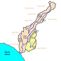
Map of Aliso Creek watershed with Sulphur Creek subwatershed highlighted
|
|
Sulphur Creek is a 4.5-mile (7.2 km) tributary of Aliso Creek in Orange County in the U.S. state of California. Draining about 6 square miles (16 km2) of mostly residential land in the southern San Joaquin Hills, it is Aliso Creek's largest tributary.
Geologically the Sulphur Creek watershed was once part of a large and shallow sea that covered most of southern California. As the San Joaquin Hills rose and river sediments were deposited, land gradually emerged to form the present-day Orange County coast. Sulphur Creek is located in a crumpled, hilly area in the southern part of this range, formed differently from the continuous mountain chain to the north. Historically, being south of Aliso Creek, the Sulphur Creek watershed was part of the territory of the semi-nomadic Acjachemen Indian group, conquered by Spanish conquistadors in the 17th and 18th centuries and renamed the Juaneño by them.
During the 19th century, the watershed became part of a rancho. In 1966, the creek was dammed to form Laguna Niguel Lake, while the surrounding hills were leveled as residential communities were constructed in the area following the '60s and '70s. The creek's basin eventually became part of the cities of Laguna Hills, Laguna Niguel, and a small portion in San Juan Capistrano. Increasing urban runoff in the 1960s caused most of the flow in the creek to be unnatural. The creek has since been channelized along most of its length to prevent floods from inundating the roads and houses that now line much of its banks.
The Sulphur Creek watershed includes parts of Laguna Niguel Regional Park and Aliso and Wood Canyons Regional Park. Despite its heavy pollution and increasing population of exotic species, for much of its length the creek is a riparian corridor.
...
Wikipedia


