Sulgrave Manor
| Sulgrave | |
|---|---|
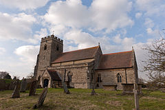
 St James the Less parish church |
|
| Sulgrave shown within Northamptonshire | |
| Area | 8.3 km2 (3.2 sq mi) |
| Population | 380 (2011 Census) |
| • Density | 49.4/km2 (128/sq mi) |
| OS grid reference | SP557453 |
| • London | 73 mi (117 km) |
| Civil parish |
|
| District | |
| Shire county | |
| Region | |
| Country | England |
| Sovereign state | United Kingdom |
| Post town | Banbury |
| Postcode district | OX17 |
| Dialling code | 01295 |
| Police | Northamptonshire |
| Fire | Northamptonshire |
| Ambulance | East Midlands |
| EU Parliament | East Midlands |
| UK Parliament | |
| Website | Sulgrave Village Website |
Sulgrave is a village and civil parish in South Northamptonshire, England, about 5 miles (8 km) north of Brackley. The village is just south of a stream that rises in the parish and flows east to join the River Tove, a tributary of the Great Ouse.
Just over 1 mile (1.6 km) north of the village is Barrow Hill, a bowl barrow beside Banbury Lane between Culworth and Weston. The barrow is oval, about 130 feet (40 m) long, 80 feet (24 m) wide and up to 6 1⁄2 feet (2 m) high. It is Bronze Age and may date from between 2400 and 1500 BC. It may have been surrounded by a ditch, but this can no longer be traced. The mound may have been re-used in the Middle Ages as the base for a windmill. The barrow is largely intact, although it has been partly disturbed by badgers. It is a scheduled monument.
Castle Hill, at the west end of the village southwest of the church, is the earthwork remains of a Saxon and Norman ringwork castle. The northern part of the ringwork was excavated in 1960 and 1976.
Evidence was found suggesting that the first construction on the site was a timber-framed hall about 80 feet (24 m) long and a detached stone and timber building, probably built in the late 10th century. They seem to have been an Anglo-Saxon manor house and separate kitchen. This was followed by the building of the earthen rampart, which is now rounded but may originally have been a straight-sided pentagon.
...
Wikipedia

