Sugarloaf Mountain (Franklin County, Massachusetts)
| Sugarloaf Mountain (South Sugarloaf and North Sugarloaf) | |
|---|---|

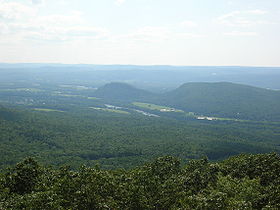
South and North Sugarloaf viewed from Mt. Toby
|
|
| Highest point | |
| Elevation | 652 ft (199 m) and 791 ft (241 m) |
| Coordinates | 42°28′22″N 72°35′51″W / 42.47278°N 72.59750°WCoordinates: 42°28′22″N 72°35′51″W / 42.47278°N 72.59750°W and 42°29′28″N 72°35′53″W / 42.49111°N 72.59806°W |
| Geography | |
| Location | South Deerfield, Massachusetts |
| Parent range | Pocumtuck Range/ Metacomet Ridge |
| Geology | |
| Age of rock | 210 million yrs. |
| Mountain type | Fault-block; sedimentary |
| Climbing | |
| Easiest route | Auto road |
Sugarloaf Mountain or Mount Sugarloaf, is a butte-like mountain located in South Deerfield, Massachusetts, United States, with two summits, North Sugarloaf Mountain 791 ft (241 m) and its more popular knee, South Sugarloaf Mountain 652 ft (199 m). Its cliffs, made of arkose sandstone, are a very prominent landscape feature visible for miles. Despite low elevations relative to the Berkshire Mountains to the west, dramatic cliff faces and a rise of 500 feet (150 m) to 600 feet (180 m) from the nearby Connecticut River make the mountain a popular tourist and hiking destination. Sugarloaf Mountain is the southern terminus of the Pocumtuck Range.
The name sugarloaf refers to the loaf-like shape that sugar was once molded into for shipment. The names Sugarloaf Mountain and Mount Sugarloaf are both used to describe this mountain. USGS sources and published hiking maps refer to (North and South) Sugarloaf Mountain. However, the Massachusetts state reservation encompassing them is called the Mount Sugarloaf State Reservation. The name Mount Sugarloaf is sometimes used to describe only the south summit, and the north summit is sometimes described as the Pocumtuck Ridge. Both names are used locally.
The original Native American name for the mountain is Wequamps (or Wequomps). The root wehqu- in this name or weckw- in Weckwannuck "Sugarloaf Brook" means "at the point of or extremity of" and occurs in placenames indicating a stopping point. According to native American myth, Sugarloaf Mountain is the carcass of a human-eating giant beaver who lived in a lake now occupied by the Connecticut River. The people complained to the god Hobomok that the beaver was greedy, and consuming all their resources. In response Hobomok decided to kill the beaver with a club he fashioned from a large tree. After the struggle, the beaver died, sank to the bottom of the lake, turned to stone, and became what is now Sugarloaf Mountain. There may be some truth to this tale; 15,000 years ago the Connecticut River from northern Vermont to southern Connecticut was post-glacial Lake Hitchcock. A now extinct species of giant beaver as big as black bears once inhabited North America at about the same time (see Pocumtuck Range for details).
...
Wikipedia
