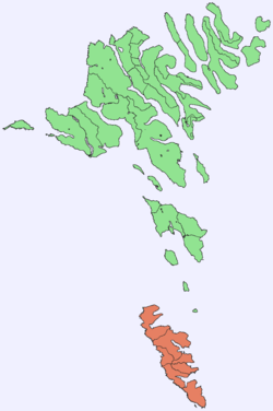
Suðuroy
|
Suðuroy Suderø |
|
|---|---|
| Island | |
 Location within the Faroe Islands |
|
| Coordinates: 61°32′N 6°51′W / 61.533°N 6.850°WCoordinates: 61°32′N 6°51′W / 61.533°N 6.850°W | |
| State | Kingdom of Denmark |
| Constituent country | Faroe Islands |
| Region | Suðuroy |
| Area | |
| • Total | 163.7 km2 (63.2 sq mi) |
| Highest elevation | 610 m (2,000 ft) |
| Population (2016) | |
| • Total | 4,603 |
| • Density | 28/km2 (73/sq mi) |
| Time zone | GMT (UTC+0) |
| • Summer (DST) | EST (UTC+1) |
| Calling code | 298 |
Suðuroy (literally South Island, Danish: Suderø) is the southernmost of the Faroe Islands. The island covers 163.7 square kilometres (63.2 sq mi). In 2012 there were 4,678 inhabitants, but there has been a gradual decline in the population numbers ever since the 1950s. In 2005 the population had been 5,036. Suðuroy region comprises this island and Lítla Dímun.
These are the settlements of Suðuroy (listed from north to south): Sandvík (re-established as a settlement in the early 19th century) Hvalba, Froðba, Tvøroyri, Trongisvágur, Øravík, Fámjin, Hov, Porkeri, Vágur, Fámara (re-established in 2010), Akrar, Lopra and Sumba.
One ancient settlement, Víkarbyrgi was abandoned late in the 1990s. Another settlement, Akraberg was abandoned around 1350 because of the black death; the people who lived there at that time came from Friesland, and legend has it that people in Hørg (in Sumba) can trace their ancestry back to this settlement, which was situated on the southernmost point of the island.
Two more settlements were started in the early and mid-20th century: Botni, north west of Vágur, and Tjaldavík, in a bay south east of Øravík. Both sites have been abandoned again.
The highest point of Suðuroy is the mountain Gluggarnir (610 metres or 2,001 feet), but the most famous peak is definitely the mountain of Beinisvørð northwest of the village of Sumba. The Beinisvørð and its scenery have been praised by the local poet Poul F. Joensen (1898–1970), as well as other Faroese poets. Suðuroy is the island which has the most islets and skerries. Suðuroy and the islets and skerries near the island number 263, including the island itself. Suðuroy is also the only island of the 18 islands of the Faroes which has coalmines, one of which is still active. It is located in Hvalba, near the tunnel. Other coalmines were in Rangabotnur in Trongisvágur (on the south side of Trongisvágsfjørður), and in Fámjin.
...
Wikipedia
