Strip District, Pittsburgh
| Strip District | |
|---|---|
| Neighborhood of Pittsburgh | |

Bustling Penn Avenue on a Saturday afternoon in summer.
|
|
 |
|
| Coordinates: 40°27′00″N 79°59′06″W / 40.450°N 79.985°W | |
| Country | United States |
| State | Pennsylvania |
| County | Allegheny County |
| City | Pittsburgh |
| Area | |
| • Total | 0.609 sq mi (1.58 km2) |
| Population (2010) | |
| • Total | 616 |
| • Density | 1,000/sq mi (390/km2) |
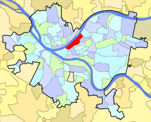
The Strip District is a neighborhood in Pittsburgh, Pennsylvania in the United States. It is a one-half square mile area of land northeast of the central business district bordered to the north by the Allegheny River and to the south by portions of the Hill District. The Strip District runs between 13th and 33rd Streets and includes three main thoroughfares — Smallman St., Penn Ave., and Liberty Ave. — as well as various side streets.
In the early 19th century, the Strip District was home to many mills and factories as its location along the Allegheny River made for easy transportation of goods and shipping of raw materials. It was the home of the Fort Pitt Foundry, source of large cannon before and during the American Civil War, including a 20-inch (510 mm) bore Rodman Gun. Early industrial tenants of the Strip District included U.S. Steel, Westinghouse, The Pittsburgh Reduction Company (ALCOA), and later The H.J. Heinz Company, famous ketchup and condiment manufacturer.
The shipping infrastructure built around the manufacturing companies attracted other types of merchants to set up shop in the Strip. By the early 20th century, the Strip District became a vibrant network of wholesalers—mostly fresh produce, meat, and poultry dealers. Soon, auction houses rose around the wholesale warehouses. Many restaurants and grocery stores opened to feed hungry shift workers at any hour of the day. By the 1920s, the Strip District was the economic center of Pittsburgh.
...
Wikipedia
