Streatham Park Cemetery
| Streatham | |
|---|---|
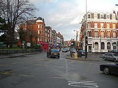
 Streatham High Road, looking north from the junction of Streatham High Road and Mitcham Lane |
|
| Streatham shown within Greater London | |
| Population | 58,055 (2011 census) |
| OS grid reference | TQ305715 |
| London borough | |
| Ceremonial county | Greater London |
| Region | |
| Country | England |
| Sovereign state | United Kingdom |
| Post town | LONDON |
| Postcode district | SW16 |
| Dialling code | 020 |
| Police | Metropolitan |
| Fire | London |
| Ambulance | London |
| EU Parliament | London |
| UK Parliament | |
| London Assembly | |
Streatham (/ˈstrɛt.əm/ STRET-əm) is a district in south London, England, mostly in the London Borough of Lambeth. It is centred 5 miles (8.0 km) south of Charing Cross. The area is identified in the London Plan as one of 35 major centres in Greater London.
Streatham means "the hamlet on the street". The street in question, the London to Brighton Way, was the Roman road from the capital Londinium to the south coast near Portslade, today within Brighton and Hove. It is likely that the destination was a Roman port now lost to coastal erosion, which has been tentatively identified with 'Novus Portus' mentioned in Ptolemy's Geographia. The road is confusingly referred to as Stane Street (Stone Street) in some sources and diverges from the main London-Chichester road at Kennington.
After the departure of the Romans, the main road through Streatham remained an important trackway. From the 17th century it was adopted as the main coach road to Croydon and East Grinstead, and then on to Newhaven and Lewes. In 1780 it then became the route of the turnpike road from London to Brighton, and subsequently became the basis for the modern A23. This road (and its traffic) have shaped Streatham's development.
...
Wikipedia

