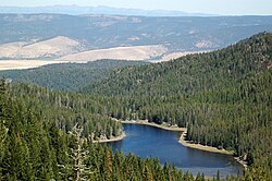
Strawberry Lake (Oregon)
| Strawberry Lake | |
|---|---|

View from the mountain
|
|
| Location | Grant County, Oregon |
| Coordinates | 44°18′25″N 118°41′00″W / 44.30694°N 118.68333°WCoordinates: 44°18′25″N 118°41′00″W / 44.30694°N 118.68333°W |
| Type | Natural, permanent, oligotrophic |
| Primary inflows | Strawberry Creek |
| Primary outflows | Strawberry Creek |
| Catchment area | 3.5 square miles (9.1 km2) |
| Basin countries | United States |
| Surface area | 36 acres (15 ha) |
| Average depth | 9 feet (2.7 m) |
| Max. depth | 27 feet (8.2 m) |
| Water volume | 300 acre feet (370,000 m3) |
| Residence time | 1 month |
| Shore length1 | 1.2 miles (1.9 km) |
| Surface elevation | 6,266 feet (1,910 m) |
| Settlements | Prairie City |
| References | |
| 1 Shore length is not a well-defined measure. | |
Strawberry Lake is a natural high-elevation body of water in the Strawberry Mountain Wilderness in the U.S. state of Oregon. Located about 10 miles (16 km) south of Prairie City in Grant County, the shallow lake covers about 36 acres (150,000 m2) surrounded by forest. Recreational activities in the lake basin include hiking, backpacking, skiing, and fishing.
Stratovolcanoes erupting about 14.7 million years ago in the Miocene covered about 500 square miles (1,300 km2) of what later became Grant County with andesite lavas and mudflows. The Strawberry Mountains are eroded remnants of the mountains created by those volcanoes and by intrusions of igneous rock.
Strawberry Lake is the largest of the small glacial lakes found in the Strawberry Mountain Wilderness. The surface of the lake is more than 6,000 feet (1,800 m) above sea level. Occupying part of a valley carved by ice in the , the lake formed behind a landslide dam across Strawberry Creek. Water from the lake does not flow over the dam except in high water but seeps through the landslide to re-form the creek several hundred yards (meters) downstream.
Strawberry Lake has an average depth of 9 feet (2.7 m) and a maximum depth of 27 feet (8.2 m). The length of its shoreline is about 1.2 miles (1.9 km). Despite water-quality problems stemming from recreational activity in the lake's drainage basin, the water remains transparent enough that the lake bottom is visible from the surface even at the lake's deepest point.
Nathan W. Fisk homesteaded in the area in 1870 and named local features Strawberry Butte (now Strawberry Mountain) and Strawberry Creek for the abundance of wild strawberries in the area, and the name spread to encompass Strawberry Valley and Strawberry Lake.
...
Wikipedia
