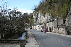
Stoney Middleton
| Stoney Middleton | |
|---|---|
 Middleton Dale from Stoney Middleton |
|
| Stoney Middleton shown within Derbyshire | |
| Population | 470 (2011) |
| OS grid reference | SK230754 |
| District | |
| Shire county | |
| Region | |
| Country | England |
| Sovereign state | United Kingdom |
| Post town | HOPE VALLEY |
| Postcode district | S32 |
| Dialling code | 01433 |
| Police | Derbyshire |
| Fire | Derbyshire |
| Ambulance | East Midlands |
| EU Parliament | East Midlands |
| UK Parliament | |
Stoney Middleton is a village in the Derbyshire Dales district of Derbyshire, England. It is in the White Peak area of the Peak District southeast of Eyam and northwest of Calver, on the A623 road at the foot of the limestone valley of Middleton Dale. The population at the 2011 Census was 470.
The village may have been a Roman settlement, perhaps based on lead mining, but there is currently no archaeological evidence to prove this. A nineteenth-century bath house over a hot spring is known locally as The Roman Baths but this was built in an unsuccessful attempt to establish a spa resort. (After the Stoney Middleton Youth Club cleared undergrowth in the early 1980s the building was consolidated and made secure by local craftsmen with the aid of a grant by the Peak Park.)
A semi-circular earth platform called "Castle Hill" overlooks the village; academic opinion varies as to what this earthwork originally was. It may have been a ringwork castle, or simply the foundations of a summer house. The origins of the name of the village go back to the Saxo-Norman period when it was known as Middletone or Middletune, the name Stoney Middleton literally meaning 'stony middle farm'.
Stoney Middleton is mentioned in 1086 in the Domesday book. The manor is first recorded as being where the King had land:
In Stoney Middleton, Godgyth had four of land to the . Land for four oxen. There 6 and one have 2 ploughs and four acres of meadow and a little scrubland. TRE as now worth six shillings.
The book then says under the title of "The lands of Ralph fitzHubert":
In Stoney Middleton Leofnoth and his brother had one of land. There is land for one plough. It is waste. This manor is one league long and 4 furlongs broad.
Local archaeologists and historians have speculated (since 1996) that the original location of the village, which was ravaged by the Black Death, may have been immediately to the south of the Old Hall, on a series of terraces (still visible from the public footpath overlooking the meadows between the lower, modern extension of the village and the bottom of the "Town" the hill by the Moon Inn which leads up to Stoney Middleton Junior School). Renewal of the village led to the construction of a stone chapel in the fifteenth century at the crossroads of the roads/tracks going between Eyam and Grindleford, which was dedicated to Saint Martin, perhaps to cater for pilgrims to the spring. The tower survives, attached to an unusual octagonal nave of 1759.
...
Wikipedia

